This is a fictional story that regards a theoretical Hurricane. The following scenario is derived from historical research and realistic data points, and is intended to present a dramatized version of events that may transpire from a possible worst-case-scenario Hurricane landfall in the Mid-Atlantic states of the U.S. East Coast. The purpose of this newsletter is to spread awareness of the danger communities along vulnerable coastlines (that have yet to be hit by a major tropical cyclone impact) with regards to the reasonable worst case scenario they may face from a tropical cyclone. No fictional characters in this episode are intended to represent real persons, unless explicitly stated by name. Additionally, this piece uses AI generated images. However, NO writing material is written by AI. It is and always will be written by myself, the author.
The Potomac River Basin. Some Native American tribes called it Cohongarooton. Others called it the Patawomeck, Algonquian for “the river of swans”, as an ode to the icy blizzard of Tundra Swans that are the region’s most populous bird species. It was the name the European explorer, John Smith, knew it by when he ventured into it from the Chesapeake Bay in 1608. Later, in the modern history of the United States of America, the river would become known for more than just its name; it was the “Nation’s River”.
The Potomac River’s 400 mile-long length links together diverse and contrasting American sub-cultures and philosophies; beginning as a dizzying maze of tributaries amidst the black, coal-stained countrysides of West Virginia and Pennsylvania; running down the rustic slopes and picturesque American Shenandoah Valley; snaking through the sticky, aristocratic spider web of Washington DC and its urban quagmire; passing inconspicuously by the nation’s Eastern ventricle of military intelligence and Naval formidableness; and emptying into the brackish, Atlantic stomping grounds of East Coast fishermen and beach-going tourists looking to get away from the cubicle office space in Chicago.
George Washington himself, the U.S.’s 1st President, practically lived his entire life within the marches of the Potomac watershed. The river alone served as the most contested piece of borderlands between the northern Union and the southern Confederacy during the American Civil War. It was then, when the Potomac was witness to some of the bloodiest and most staggering ramifications of modern warfare ever recorded in the Western Hemisphere, such as the Battles of Antietam in 1862 (which resulted in the single bloodiest day in American history, when over 23,000 men fell as casualties on the gruesome battlefield), and Gettysburg the following year. The basin is as rich in wholesome American heritage, as it is tarnished with the dark blemish of innocent people’s suffering.
From the climactic, yet tragic, triumphs of the siege of Yorktown in 1781; to the greater than 10,000 American soldiers and Confederate rebels slaughtered on these fertile grounds; the valiant struggle of maltreated coal miners, inhaling pounds of toxic black death every month they worked in the underground pits of pre-OSHA carbon Hell; to the devastating and costly Great St. Patrick’s Day flood of 1936—Eastern Virginia and the Potomac River Basin are not chaste from the stinging venom of deadly and destructive disasters… manmade, or natural. But from the meteorological perspective, there exists a critical, largely unrealized weakness in Virginia’s bone structure. It is a weakness that cannot be exploited by heavy rains or simplistic, straight-line thunderstorms. No—the only key that fits into this padlocked safe of disaster, is the sledgehammer force of a Major Atlantic Hurricane.
The weakness in question lies embedded in Virginia’s Atlantic coastline. It begins at the massive, inlet knife-shaped cove of Chesapeake Bay, a mid-latitude lough that, from space, looks like the puncture wound of a hooked stingray barb into America’s Eastern Seaboard. But the Chesapeake serves only as the front door to a long and winding maze of river corridors, tidal flats, and tributaries that penetrate directly into some of the Mid-Atlantic’s largest, most populous urban cities. It is one of the most storm surge vulnerable coastlines that can be found in the United States… yet, very few, if any, Atlantic Hurricanes have ever taken advantage of this.
There was a storm in 1769 that struck the region during early September, causing severe wind damage to the colonial infrastructure. Subsequently, a much more violent system in 1821 hinted at the Chesapeake’s surge susceptibility more readily, producing a 10 foot deep tidal wave on the Delmarva Peninsula after a landfall in North Carolina, as a Category 4 Hurricane. But by far the most damaging storm for Virginia’s Tidewater Region (and perhaps even the Mid-Atlantic states as a collective), was the aptly named Chesapeake-Potomac Hurricane. The system made landfall over Nags Head, North Carolina on August 23rd, 1933, as a large, Category 2 Hurricane. The angle of landfall was nearly perfect for the tropical cyclone’s storm surge to take full advantage of Chesapeake Bay’s cup-like coastline, resulting in a record-high tide of 9.8 feet that was recorded in Norfolk, Virginia; the Elizabeth River, which curls right into the heart of the city, allowed the tidal wave to inundate even the downtown areas as well, with up to 5 feet of flooding measured in most of the city.
The record-setting impacts of the Chesapeake-Potomac Hurricane would not be challenged until almost exactly 70 years later, when Hurricane Isabel (whom we covered in our last episode) made landfall in September of 2003. Isabel would surpass the ‘33 storm as the costliest Hurricane impact in Virginia’s history; however, her damage came more from rain-induced inland flooding, rather than saltwater surge at the coast.
But now, imagine that there was a storm that perfected every trial, equation, and criterion necessary to exploit the Chesapeake/Potomac’s crippling defenselessness to Hurricane surge (the entire basin is either at, or even below, sea-level)—with the greed and vocation, of a remorseless businessman. Imagine that you are a storm chaser, or an avid weather enthusiast (both of which you already may be), or even a resident of Virginia’s beaches; and one cold morning, you wake up to a sight that sears your eyes more frightfully than the burning oil of sausage cooking on the scorching steel griddles of a barbecue grill:
BULLETIN
Hurricane Imani Intermediate Advisory Number 55A
NWS National Hurricane Center Miami FL
7 AM EDT Thu SEP 9 2027
…AIR FORCE RESERVE RECON MISSION FINDS IMANI RAPIDLY INTENSIFYING. CATASTROPHIC AND LIFE-THREATENING CONDITIONS LIKELY FOR THE MID-ATLANTIC SEABOARD…
…MAXIMUM SUSTAINED WINDS ARE NOW 145 MPH…SAILDRONE REPORTS 931.2 MB IN THE EYE…
It’s September 9th—the year, is 2027. A major, Cape Verde Hurricane of scorching power, unimaginable size, and a redefining volatility of forward motion, is careening towards the Mid-Atlantic’s weakest link in the shoreline chain. It’s a Hurricane that will combine the worst intentions of the 1769, 1821, 1933, and 2003 (Isabel) storms, all rolled into a single, catastrophic grapefruit of bitter temperament, and with a lust for human catastrophe.
August 27th—14 Days to Landfall.

In the streets of Dakar, Senegal—a city of 4 million people, whom are neatly packed along a tiny Atlantic peninsula that resembles the shape of a fishing hook—taupe flows of water are rushing down the winding, sharply angled streets. Thunder rumbles overhead, in the growl of the Saharan air. Flocks of Dakar’s residents amble through the streets on their daily commute, creating a sea of colorful umbrellas that look almost like a meandering river of playpen plastic balls. The rainstorm has been going off and on for a day, now; a glimmer of light on the Eastern horizon tells of an end to the squalls coming soon. This was the second prolonged thunderstorm event in the last two weeks, recall Dakar’s citizens, as they crane their heads upwards for brief glances into the wet, gray void, blinking away the raindrops that splashed their eyes.
Unknowing to the people of Dakar, but the drops of rain falling on their skin are of no ordinary nature. Locked inside those polar-bonded molecules of hydrogen and oxygen, an impulse of vortical spin stands in the corner of the dance hall, waiting for the culmination of moist air, water vapor, and instability to notice her standing there, and to ask her to dance. Together, they form the pre-cambrian seed of all Hurricanes: the tropical wave.
Forecast models identify this wave as a possible area of interest as early as August 23rd, 2027; a day later, the National Hurricane Center highlights the area just south of the Cabo Verde islands as having the potential to develop a tropical cyclone. 7-day probabilities are initially labeled at 20%; this rises to 40% by August 25th, and then to 70% on the 26th. Later that Thursday (on the 26th), the wave is officially marked as an Invest, and given a 30% chance of tropical cyclogenesis in the next 3 days.
Under relatively conducive environmental conditions, the Invest begins to develop a tentative low-level circulation. ASCAT scans over the circulation on the 26th show a closed low pressure gradient near a lightly defined center; the NHC does not issue advisories, however, until late in the evening the following day, August 27th. In their first bulletin (the one that upgrades the Invest to Tropical Depression 10), the Hurricane Center notes the likelihood of gradual organization during the next couple of days, and the possibility for more significant intensification down the road.
At 2 pm EDT, August 28th, Tropical Depression 10 is determined to have sustained winds of 45 mph based on satellite estimates, and the NHC christens the system Tropical Storm Imani, the 9th named storm of the 2027 season. It is the first time the name Imani is used for an Atlantic cyclone, as it was the replacement name for 2021’s Hurricane Ida (whom was retired after causing devastating damage to Louisiana’s Gulf coast as a high-end Category 4). As predicted, initial organization for Imani remains slow. Dry air, curling off Africa’s Saharan basin, continually erodes the young system’s early blowups of convection, entraining into her babyish cloud levels. Microwave passes on the 28th and 29th show intervals of slim, convective structures attempting to form a ring around the center… only to see them repeatedly erode several hours later. During this time, Imani’s winds increase only slightly to 50 mph, while central pressure is estimated to hover around 1,000 millibars.
Finally, around AST dawn on August 30th, conditions begin to improve. While located at coordinates 18°N 33°W, Imani’s westward motion brings her out of the choking cloud of Saharan dust, and into wetter, tropical air layers. Cold convection, chilling to temperatures nearing -110℉, billows up around the core and covers the LLC (though overall organization remains relatively shoddy). Satellite estimates increase the tropical storm’s sustained winds to 60 mph; but only for isolated, sporadic quadrants of Imani’s broad wind field.
Looking ahead, however, the NHC 5-day forecast cone is becoming more bullish with its own intensity forecasts, now predicting Imani to become a 125 mph Category 3 Major Hurricane by September 3rd. Already, meteorologists and social media personalities in the weather community are fixating on whether model ensembles are indicating that Imani is going to turn out to sea, or remain to the west, and pose a threat to the continental United States (CONUS). In their 5 pm EDT bulletin on August 30th, the NHC writes:
NWS National Hurricane Center Miami FL
500 PM EDT Mon Aug 30 2027
…IMANI PREDICTED TO REACH MAJOR HURRICANE STATUS BY THURSDAY…
…12Z GFS RUN INDICATES SLOWER TROUGH MOVEMENT ON US EAST COAST THROUGH FORECAST HR 240, WHICH COULD ALLOW MID-ATLANTIC RIDGING TO BE STRONGER THAN INITIALLY ANTICIPATED. IT IS TOO EARLY TO DETERMINE IF IMANI WILL BE A THREAT TO THE EAST COAST…
The language is cautious, but lends itself to those reading that the possibility for Imani to run south and west of the current forecast cone is a real one. Still, there is high uncertainty, and the inevitable bickering between weather enthusiasts about if Imani will make it to the U.S., or simply be a harmless ‘fish storm’, ensues heatedly.
On August 31st, things start to change more radically within Imani’s dark underbelly. Her internal dynamics—namely, the vertical alignment of her thunderstorms through multiple atmospheric layers—have been gradually coming together over the last several days. Now, stacked and properly arranged, Imani’s core starts to consolidate. The first real drops in pressure are detected by satellites, and that evening, Imani intensifies below 990 millibars. As the sun sets on the swirling system, the first signs of vortical hot towers pop up on infrared imagery, appearing as embedded spines of gray in Imani’s primary, backbone rainband. The hot towers rise, burst, and then expand rapidly, like water spreading out from a popped water balloon. At 11 pm EDT, August 31st, the NHC, based on visual patterns using the Dvorak-technique, determine that sustained winds in the system have surpassed ~74 mph. Hurricane Imani, is born.
While continuing to move near-due west, Imani slowly strengthens through the night and into September 1st. Convection grows more solid and consistent, swirling around the core, and tightening with every revolution. Imani’s eye is not yet visible, but it’s clear enough that the center of circulation becomes visually apparent. With the air now efficiently sinking in Imani’s core, organization accelerates. By 11 am EDT, September 1st, the storm reaches 80 mph; by 5 pm EDT, 90 mph; and just 24 hours after attaining Hurricane status, Imani rolls past 100 mph, crossing the Category 2 threshold. At this point, the muscle of the sinking air in the eye beefs up. The core clears itself of clouds in a flash, opening an eye that had been completely closed just an hour beforehand, and visible satellite detects the bluish-white flashes of lightning bolts suddenly appearing in Imani’s eyewall. These signs indicate that rapid intensification is now imminent by the afternoon of the 1st.
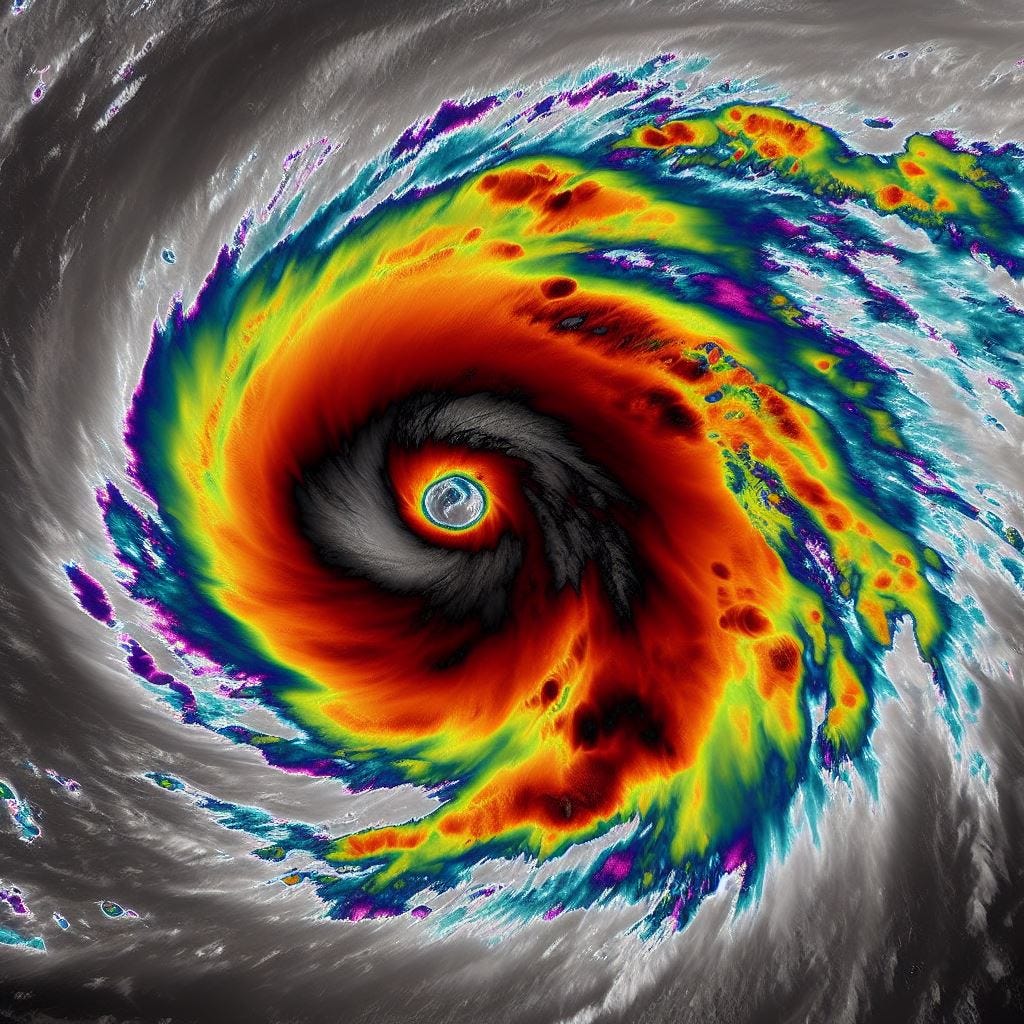
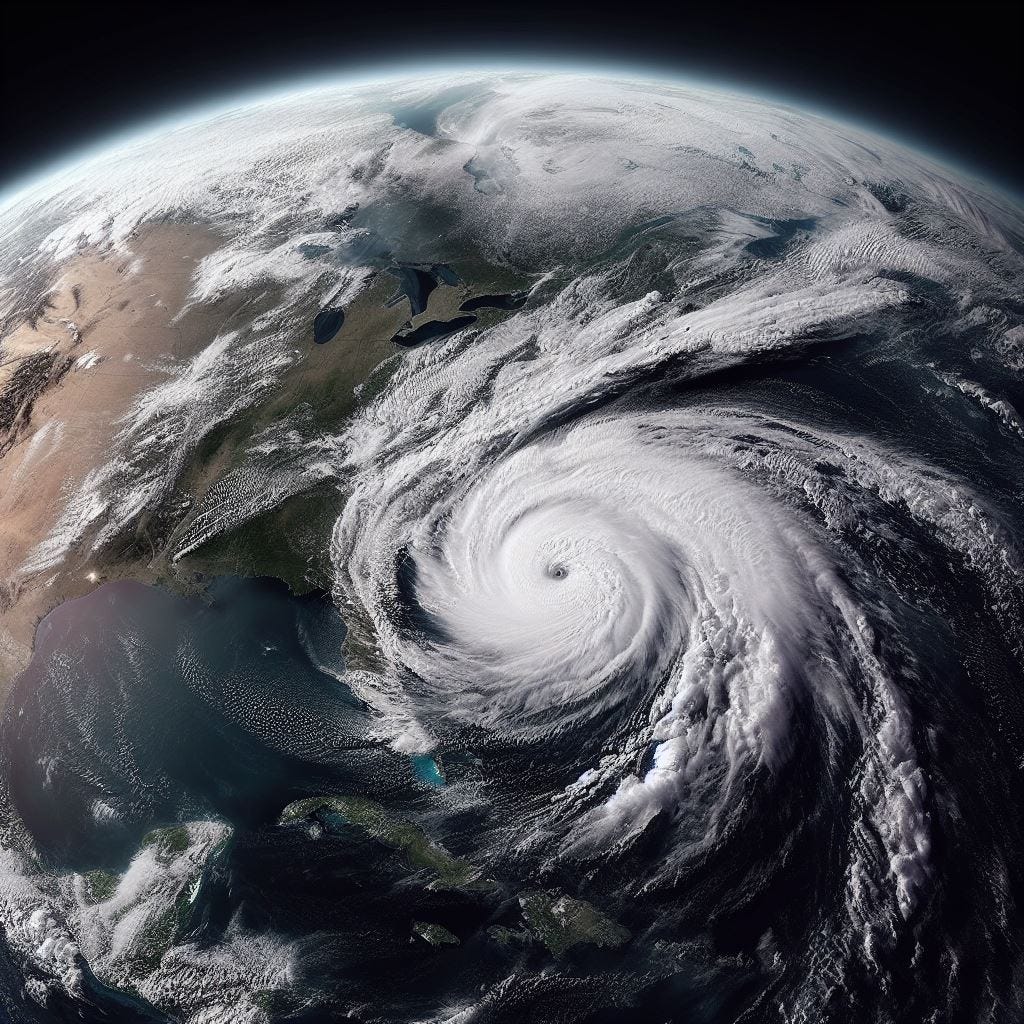
Overnight on September 2nd, the charitable, warm SSTs of the Central Atlantic brings Hurricane Imani to an ecstasy of swirling power, blossoming her bitter, convective flesh. When the sun rises over the horizon later this morning, shadowing the storm’s bubbling cloud tops like a melted, boiling marshmallow over the flames of an oceanic campfire, Hurricane Imani reaches maximum sustained winds of 135 mph, and a plummeting minimum pressure of 944 millibars, making her a low-end Category 4 Hurricane. Her appearance is starkly classical, with well-defined rainbands arching out from her periphery, and exceptional cirrus-cloud outflow patterns.
Down on the ocean surface, the crew of the American cargo ship SS El Capitan, who has failed to steer clear from Hurricane Imani’s predicted path in time before her rapid intensification phase hit, find themselves in the wet bowels of inglorious, cyclonic viciousness. Located at coordinates 20°N 46°W, Imani’s rain and wind lash the ship pitilessly, cascading a half fresh, half saltwater deluge upon the vessel. El Capitan rocks and creaks with the swells of 20+ foot waves, becoming David to the Goliath that was Imani. The ship’s crew scrambles to fasten down any one of the hundreds of cargo containers strapped to the deck, racing through the sloshing puddles of water in rubber boots and waterproof coats, straining to keep their balance with the swaying of the ship. The rain is poetically intense, coating, spraying, splashing, dripping, and caressing every hard, metallic inch of the ship. Crane wires rattle and ache. The American flag on the ship’s stern rips at the seams under the duress of the relentless wind. Through the window panes on the bridge, El Capitan’s Captain squints through the silvery crystals spraying on the glass, and watches as the Atlantic’s beastly waves, foaming and brutish, rise up and smash the bow with a reverberating force. The fury is terrifying—but after a couple hours, the El Capitan is able to navigate out of Hurricane Imani’s eyewall. They continue to experience stressfully tempestuous conditions for the rest of the day; but for them, the worst is over. They comfortably survive their dangerous flirt with the Category 4 storm, with just one crewman injured.

As mainstream interest in Hurricane Imani grows alongside her power, experts and officials are increasingly being bombarded with questions from people as far north as Rockport, Maine; and as far hot as Fort Lauderdale, Florida. “Will Imani hit us here in Charleston? When should we start preparing? Is it going to make it to the East Coast? Will it be a Category 5?” For the most part, authorities can only respond with the only rational answer: “We just don’t know yet…”
Back in the Hurricane’s heart, a bar fight is brewing inside the Central Dense Overcast (CDO). The daytime hours of September 2nd are closing, and with them, so is Imani’s time at Category 4 intensity. “X-ray” scans of the storm, using microwave imagery, reveals one of Imani’s rainbands is beginning to become more reflective; ie, stronger, and more robust. The rainband closes in on the system’s eyewall, and by 11 pm EDT, the first signs of an oncoming Eyewall Replacement Cycle (EWRC) is represented by the slight tweaking of the Hurricane’s winds, from 135 to 130 mph. On infrared, the small, previously crystal clear eye fills in with clouds, and the CDO becomes lopsided on its eastern quadrant. Imani, after spending her afternoon as a flawlessly spinning saw blade, now appears more reminiscent of a flat tire lolloping down a lumpy Irish road. 12 hours later, Imani stumbles down to a 115 mph, minimal Major Hurricane—and many think this is a generous estimate, considering the substantial warming her cloud tops have undergone.
Nevertheless, the latest model runs remain aggressive on the intensity side, showing Imani’s weakening as a result only of moderate northwesterly shear (which is forecast to subside as quickly as it appears), and the Hurricane’s internal dynamics. With fluctuations in strength, expected of long-tracking Cape Verde storms, the NHC stresses the Hurricane may very well become stronger again in the near future. In the meantime, the numerical globals continue to struggle with the interplayed timing of the Mid-Atlantic ridging and the frontal trough—but a greater cluster of spaghetti ensembles, as pointed out by online observers, seem to be joining the “landfall camp”. The tracks in favor of the U.S. impact show Imani, on September 8th and 9th, briefly slowing her forward speed (almost to a stall-out) roughly 100-150 miles south of Cape Hatteras, North Carolina, before accelerating north-northeast, with a possible landfall anywhere from Myrtle Beach, South Carolina to the Outer Banks. But with Imani still 7 days out from being in flirtatious proximity to the East Coast, these runs are still taken with a grain of salt. A few communities in the Carolinas begin light preparations, stocking up on some typical hardware and grocery supplies.

Back to Hurricane Imani herself, the spinning storm spends most of September 3rd with her ducks in anything but a row. The EWRC process has disrupted her tedious layers severely, untucking her bed sheets and throwing them haphazardly on the floor. But the secondary rainband—the new, primary eyewall-to-be—assures Imani that the pain will be over soon… and that the subsequent gain, will be exquisite.
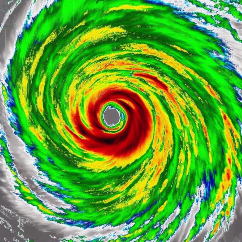
Sure as rain, by the darkly hours of September 3rd-4th, Imani’s re-organization is quite literally, wrapping up. New plumes of convection sprout near the eyewall once again, crackling with fresh jolts of adrenaline-filled lightning. The northwesterly shear subsides as expected, relieving the pressure off the chest of Imani’s outflow. Renewed bursts of deep moisture, fed by the conversion of warm water vapor from the Atlantic’s surface, rocketing up through the eyewall to form icily frigid thunderstorm densities, push out a troublesome southwesterly slot of dry air that had penetrated Imani’s core while she was undergoing the EWRC. The CDO is chilled back down to operating Major Hurricane temperatures, dropping below -110℉ in some of the strongest convective rings in the northern half. The new eyewall starts to sticky roll the hairy wisps of clouds in the storm’s eye (which has now nearly doubled in diameter) by converging the air down through the center, drying the environment and evaporating most of the remaining water vapor.
After holding at 115 mph (with corresponding pressures revolving around the upper 950s millibars) for 18 consecutive hours, the fruits of the painful and laborious EWRC are finally realized. Upon the 11 am NHC Advisory on September 4th, Hurricane Imani’s winds are rising again, coming up modestly to 120 mph. Being pinpointed at 22°N 55°W, and therefore within range of the Hurricane Hunters, the first WC-130J of the 53rd Weather Reconnaissance Squadron takes off from Puerto Rico later that evening to investigate the storm. The flight intercepts Imani ~513 miles northeast of Barbuda; and inside the powerful Hurricane’s depths, the WC-130J records flight-level winds near ~165 mph in the northeast quadrant of the eyewall. As a result of the astounding findings, the NHC issues an intermediate advisory at 8 pm EDT September 4th, marking Imani’s sustained winds at 140 mph… a 15 mph increase from the complete advisory 3 hours previous. In addition, a dropsonde released by the plane inside the 38 mile-wide eye measures translated surface pressures at an incredible 937 millibars, easily surpassing Imani’s initial peak intensity by 7 millibars.
Intensification persists throughout Mission 1’s multi-hour flight; and by the WC-130J’s last criss-cross through the eye, the pressure has already fallen further to ~929 millibars (though the NHC plays conservative in the 11 pm EDT update, opting to award Imani with 932 millibars/145 mph). The new eyewall doesn’t stop here, pushing the eye deeper, warmer, and drier. The air convergence is stiffly mechanical, and determined, descending like an elevator to the ground floor of a Category 4’s limits.
The dawn of September 5th unveils a storm of immense prowess and cyclonic faculty, now bathing in the light of day for the whole world to see. And, in an almost Parnassian, terrifyingly artistic irony, it is this morning of September the 5th, when the newest forecast cone formally touches the Outer Banks of North Carolina on its extreme, western edge for the very first time. Model consensus is very slowly agreeing on a slower trough on the East Coast, thereby leading to a stronger ridge to Imani’s north September 8th-onward (which would block any possible northern turn for the system until very late on the 10th, enabling a U.S. landfall). Now, Hurricane Imani’s existence spreads more widely across mainstream news channels and social media outlets. Headlines are published everywhere; some decry the predictions as “fear-mongering”, while others falsely claim that Imani is predicted to make landfall in North Carolina as a ‘Category 5’. Screenshots of a cherry picked model ensemble, showing an erroneous scenario of a landfall in New York City, go viral faster than rodents reproducing in a subway tunnel. On X, “#HurricaneImani” becomes the #1 trending topic in the United States.
Upon the 11 am EDT complete advisory on September 5th, Hurricane Imani’s new peak intensity continues to augment, with the first pass of the Hurricane Hunter’s second mission into the storm reporting back maximum sustained winds of 150 mph, and an extrapolated surface pressure of 926 millibars.
During the rest of the mission, Imani’s strength levels-off, with very similar data numerics recorded on each subsequent penetration of the Hurricane’s eyewall and core. At this time, the storm, having taken on a more northerly vector in her forward movement, is located over ~500 miles northeast of San Juan, Puerto Rico.
Now, things are becoming much more serious. State authorities in the Carolinas, Virginia, Maryland, Delaware, and New Jersey are privately warned by government meteorologists that they could be dealing with a large and powerful Cape Verde Hurricane making landfall in their states within five days. The Governor of North Carolina, former pro-wrestler Ric Flair, asks if the impacts would be comparable to Dorian from 2019, or Florence from 2018. An NHC official responds, “While the inland impacts likely wouldn’t be as bad as it was in Florence, there is the possibility that if Imani’s internal dynamics hold, the angle at landfall could be much more devastating for the coastal counties.”
Imani holds 150 mph for the entire day of September 5th; and now, she is churning up fear in the pits of people’s throats as much as she is the Atlantic Ocean. Her new eyewall has held true to its promise, achieving and maintaining a much greater size and intensity than its predecessor had. It becomes clear to forecasters that, even if the Hurricane weakens, her sheer size will bring very severe impacts to the Carolina coastline regardless of whether she’s a Major Hurricane or not. Many conclude that the impacts will be comparable to Hurricane Isabel’s destruction 24 years previous in 2003.
The tick, tick, tick of the hands on the Clock are officially, undoubtedly, and indisputably descending the decibels of time and inevitability. The ensemble members of both the American and European forecast models converge in indisputable agreement. It is no longer a question of if there will be a U.S. landfall. Now, it is just a question of time…
September 7th—3 Days to Landfall.

The day is September 6th, 2027, and millions along the U.S. East Coast have their eyes glued to the white light of the TV screen. The sporadic news reports on Category 4 Hurricane Imani have now shifted to wall-to-wall coverage over the last day, and real concern is setting in among residents of coastal communities within the cone of uncertainty. In the latest advisories from the NHC, the cone itself is starting to swell at its end, indicating broader disagreement between model ensembles after/as Imani is forecast to make landfall in the U.S. The cone now reaches from Emerald Isle, North Carolina to Ocean City, Maryland, encompassing a 270+ mile stretch of the Eastern Seaboard where Imani could possibly make landfall. This sudden uncertainty has stemmed from the Hurricane’s forward motion: since mid-afternoon on the 5th, Imani’s coordinates, as registered by the Hurricane Hunter flights and satellite fixes, have been riding the very southern edge of the near-term forecast cone. People on social media overlay the eye’s movement with the predicted track, showing clearly the storm’s definitive drift to the south. This means that ridging north of Imani is even stronger than thought, and is keeping the storm on a due west trajectory (as opposed to the more northwesterly vector predicted). As a result, the cone has become a fat L-shape, with Imani possibly coming as close as ~350 miles east of Cape Canaveral, Florida late on September 8th, before curving northward and striking the Outer Banks from the south on the morning of September 10th.
Returning to Imani herself, her second eyewall is now receiving a bitter taste of its own medicine. After enjoying more than 48 straight hours being the smoothly running engine in the supercharged Category 4 monster, the inevitable struck again: yet another, parasitical rainband was closing in on the primary, looking to sabotage, suffocate, and feed off Imani’s internal structure for its own self-interests. The eyewall is forced to swallow the terrible, vitriolic truth: its reign of dominance, is over.
Imani’s second EWRC ensues, and an argument can be made that it looks even more agonizing and implosive than the first. In a grandiose collapse, the Hurricane’s eyewall appears to plunge inward, smothering the eye’s face in a pillow of clouds. With Imani unable to breathe efficiently, her winds don’t have enough fresh, moist air to extract energy from, and thus, they subside. The tedious cloud structure falls off its pedestal, becoming less resilient a fortification to the harsh, outside environment. With the weakening, Imani’s diameter of tropical storm-force winds once again inflates, now stretching to well over ~330 miles across.
By September 6th, serious preparations are now underway in the Mid-Atlantic states. Tropical Storm and Storm Surge watches are charged to every county between Brunswick and Worcester. Voluntary evacuations are issued for Morehead City, NC, as dozens of neighborhoods are preliminarily put under 6-9+ feet of storm surge, in the reasonable worst case scenario maps released by the NHC. The barrier islands of the Outer Banks descend beneath the terrifying haze of Mandatory Evacuation Zones, which are issued for Carteret, Pamlico, Hyde, Dare, and Pasquotank Counties. Across eastern NC, hardware, grocery, and convenient stores become mobbed, while gas stations struggle to keep their reservoirs filled. Plywood becomes the new in-vogue exterior design for homes, as families board up the windows of their beach houses. In Virginia Beach, where 3-5 feet of storm surge is forecast, hundreds of sandbags are delivered to the city, while thousands more are being filled on the beach. They’re stacked in front of store fronts and homes by groups of volunteer workers and residents.
Meanwhile, the new uncertainty in Imani’s track has forecasters scrambling for a more definitive answer. On a live X-Spaces recording, the director of the National Hurricane Center is questioned by multiple independent journalists on why the models are going backwards, instead of collectively increasing in their confidence as Imani neared closer to landfall. Past storms, such as Hurricanes Ian and Otis, are used as allegories of egregious forecast errors unusually close to landfall. The Spaces is reposted over 30 thousand times.
The reality of the uncertainty once again involves the speed of the approaching East Coast trough. A divergence has formed between the 18Z September 7th GFS and European model runs, and the choices are a pick-your-poison roll of the dice: the former predicts a landfall just east of Morehead City, NC, a scenario which would crush Emerald Isle, Beaufort, and the surrounding shoreline with a devastating storm surge—while the euro favors a faster trough that picks up Imani earlier, preventing a direct U.S. landfall altogether, instead hugging the storm parallel to the curves of the Eastern Seaboard, from the Outer Banks to New Jersey. In the latter scenario, the theoretical damage would be less concentrated, but spread out over a wider area, where massive coastal erosion, inland flooding, and widespread power outages would be the primary threats. In their 11 pm EDT advisory that night, the NHC opts to split Imani’s track evenly between the GFS and Euro:
But it isn’t just the track divergence that is bubbling Imani’s cone of uncertainty at landfall… it is also her speed. With the potential conflict of blocking ridges—one in Atlantic Canada, the other near Bermuda—meteorologists realize that the Hurricane’s forward motion by landfall will be very slow, possibly around ~5 mph. With no clear escape route opening up to the Arctic until very early on the 12th, the possibility for Imani to closely resemble what Hurricane Florence did (with catastrophic inland flooding in 2018) grows. The Florence analog was impeccable: a large, long-lived Cape Verde Hurricane, peaking as a Category 4 out at sea, weakening to a high-end Cat 1/low-end Cat 2 by landfall, creating a colossal swath of deadly and destructive flooding by stalling out, and dumping massive quantities of rain. The comparison is the new headline selected for plastering on every mainstream news outlet that day.
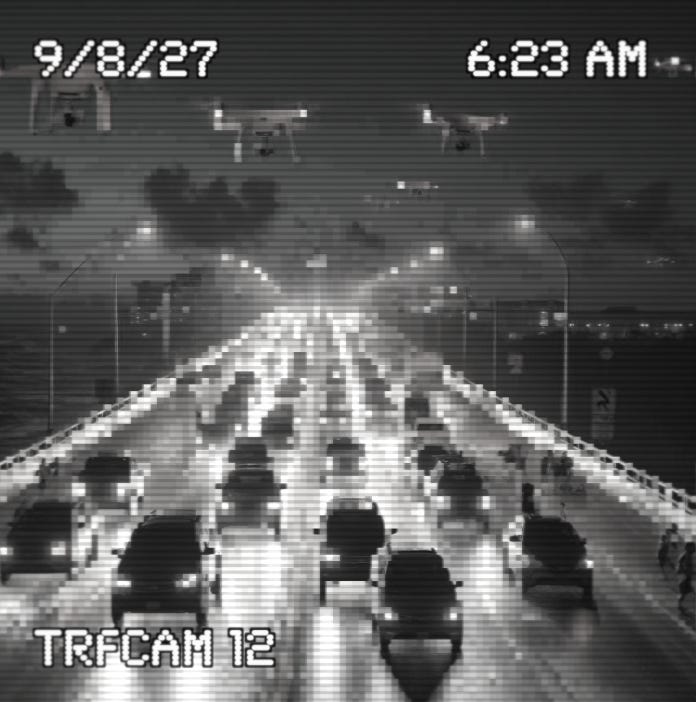
At 1 am EDT on September 8th, mandatory evacuations are hastily expanded: Onslow, Craven, Tyrell, Wrightsville Beach, Emerald Isle, Indian Beach, and Atlantic Beach in NC, and every coastal county south of Westmoreland in Virginia. Immediately, criticism is thrown at local officials for not calling the evacuations days ago, as people in the Outer Banks are awakened in the middle of night to their phones, fridges, and televisions buzzing loudly with the evacuation notices. Later this night, during the bluish-black bruise of pre-dawn light, dense traffic jams on the roads and bridges of the Outer Banks block up vehicle flow like a clot of plaque in an unhealthy aorta. Seen for miles and miles around, the bridges glow like winding, luminous candy canes in the foggy Atlantic night.
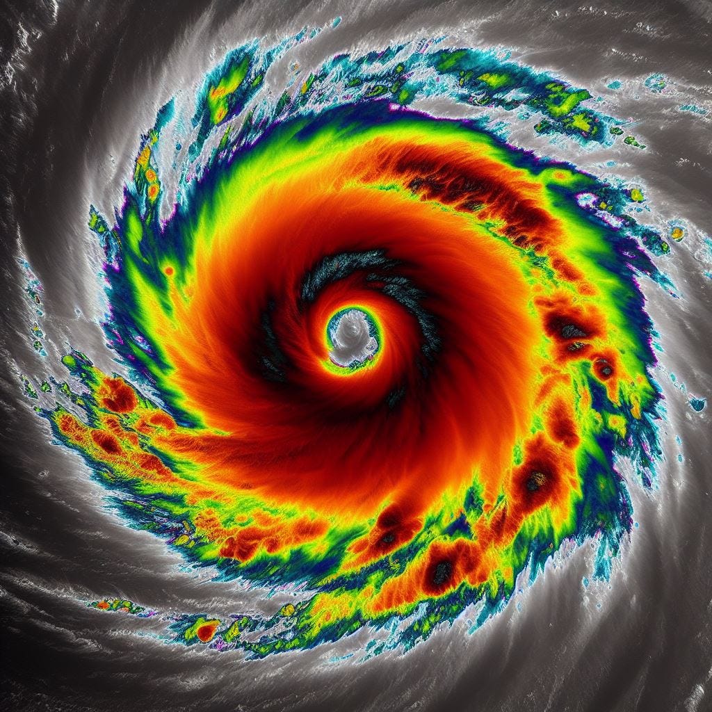
735 miles southeast of Cape Hatteras and the Outer Banks, the spinning ice skater that is Hurricane Imani’s eyewall continues to let her arms hang out, slowing her icy twirl. As the case was with the first, the second EWRC is not looking to be a quick and painless experience for the storm. Microwave scans at 12Z show the primary core mostly dissolved, and the suspected killer rainband appears to have only partially fallen into place, resulting in an uneven mote wrapping through Imani’s CDO. This weakness in the Hurricane’s convection allows a slot of dry air to penetrate the fragile thunderstorm layers, causing a dark curl to drape gently over Imani’s eye. The swirly aesthetics prompt internet memes comparing Imani to a cinnamon roll, to run rampant.
At 1 pm EDT, September 8th, the steering currents start to drop away much sooner than anticipated, at a distance over ~450 miles east of Cape Canaveral, instead of the ~350 that was predicted. The drop away forces friction into Imani’s forward movement, in turn slowing her velocity greatly (which induces upwelling of cooler waters beneath the storm’s core, thus working with the EWRC to weaken Imani below Major Hurricane status for the first time since the 1 am EDT intermediate advisory on September 3rd). Hurricane Hunters find Imani’s winds around 110 mph, and a rising pressure of 945 millibars. As the afternoon wears on, the inverse relationship of wind and pressure persists the trend, withering Imani to 105 mph/950 mb., and then 100 mph/954 mb. The Hurricane seems to level off here; still very impressive in her size, presence, and symmetry, but no longer retaining the frosty power and hard, voluptuous curves she once had. Because of this rather non-intimidating social status as a “low-end Category 2”, many people in North Carolina change their minds about leaving their homes, figuring that if they or their parents/friends survived past storms such as Isabel or Florence, then they would likely fare just fine in the face of another Cat 1/2 storm at landfall. Indeed, the vast majority of intensity models maintained Imani under Category 3 strength up to landfall, after she’d initiated the second EWRC.
Surf, swells, and waves crest to foaming heights from Miami to Long Island. Seawater surges up beaches for hundreds of miles both north and south, eating away at sand dunes and clawing small channels in the loose earth. Rip currents run roughshod, swarming towards daring swimmers and ambitious surfers more hungrily than a shark. Imani’s first direct deaths are 7 people who drown in the rowdy, animalistic surf, between September 6th and 9th.
With the first arrival of the Hurricane’s furthest flung rainbands, and the murmur of Imani’s winds, fear and lawlessness converges in the minds of the people under the red mist of the cone. Some follow their neighbors, fleeing worriedly; some laugh, and hold their ground defiantly; and some notice, as Imani begins to lift north, the slight eastern stray her center takes from the predicted track line.
September 9th—24 Hours to Landfall.

The National Hurricane Center releases Tropical Storm and Hurricane Warnings at 2 pm EDT, September 8th, from Wilmington to Corolla, NC. Three hours later, TS Warnings expand to include the entire coastline of Virginia and Delaware. Because of Imani’s northward turn taking place over ~100 miles further off the Florida coast than forecasters anticipated, a new trend in the GFS ensembles immediately follows. Track consensus shifts well to the east, growing an unsettling feeling for counties such as Currituck, Northampton, and Accomack, where less urgency had been communicated by local authorities, since these areas had only been predicted to receive moderate, mostly coastal storm surge. Now, an increasing number of spaghetti runs take the Hurricane’s core straight into them.
Concurrently, Hurricane Imani is wrapping up a nearly 3 day long period of turmoil and gradual weakening. With the deployment of several NOAA saildrones into the core of Imani, the data they stream back tells an ominously prescient tale. Deciphered first by online Hurricane trackers, the saildrones’ raw data logs are no longer recording a double wind maxima in the Hurricane’s core. This meant that the EWRC has finally completed… but there is more. Extrapolated surface pressures from the Hurricane Hunter missions insist on Imani’s eye holding in the low 950s millibars; but the surface measurements taken by Saildrone 24 paints a much different picture, this one with a ~943 millibar brush. These numbers aren’t confirmed by air reconnaissance until 3 hours later, at 5 pm EDT, September 8th. Then, another 3 hours after this, the NHC issues this:
NWS National Hurricane Center Miami FL
800 PM EDT Wed Sep 8 2027
…IMANI STRENGTHENING AGAIN…
…RECONNAISSANCE FINDS MAXIMUM SUSTAINED WINDS ARE NOW 110 MPH, AND MINIMUM BAROMETRIC PRESSURE HAS FALLEN TO 946 MB. FURTHER STRENGTHENING IS POSSIBLE AS THE CORE MOVES OVER THE WARM WATERS OF THE GULF STREAM, AND IMANI COULD BE A MAJOR HURRICANE AT LANDFALL…
The Gulf Stream… a sea current of galvanizing heat content and influential climate dynamics. It curls around the tip of Florida, parallels the East Coast up to North Carolina, and looks like an intoxicating red trail of smoke being blown from the Gulf of Mexico’s “lips” (ie, the Florida Straits) on a sea-surface-temperature map. As Imani’s thirdborn, hungry eyewall wanders into these wafting curls of delightful, warm delirium, another phase of intensification begins. With every mile she churns forward, Imani picks up more and more of these loose parcels of moisture, rumbling in the rapturous chant of virile motivation.
Imani re-attains Cat 3 strength at 11 pm EDT, September 8th, while located at coordinates 33°N 72°W—243 miles east-southeast of Cape Hatteras, NC. Many people—even those who had been following the storm—don’t realize how significantly Imani is shifting to the east until this official NHC bulletin updates the storm’s fix and position. But the real panic for previously unsuspecting residents—namely, in Virginia—doesn’t set in until the new track forecast is released in the complete advisory, which does not come out until 2 am EDT, September 9th:
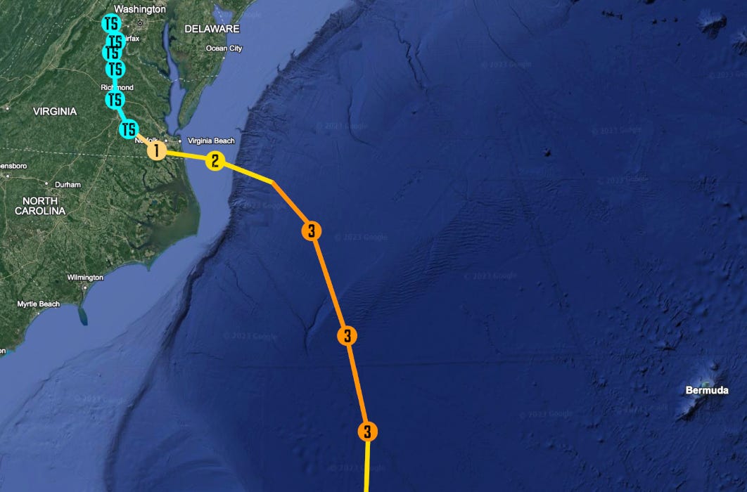
In an earth-quaking shockwave, the long envisaged landfall in North Carolina’s Outer Banks is circumvented almost entirely. The focus suddenly reorients towards Virginia, Maryland, and Delaware, as they are now firmly in the crosshairs to receive a direct, onshore push of seawater. Additionally, the catastrophic severity of inland flooding is not fully recognized until that fateful, 2 am EDT advisory on the morning of the 9th, when modeled QPF’s across Virginia’s countryside show totals possibly exceeding a staggering 30+ inches of rainfall. Hurricane Imani is not just going to be a coastal disaster… but a prolonged, inland calamity of appalling proportions.
If matters couldn’t get any worse, the hallucinogenic dopamine of the Gulf Stream is beginning to take effect in Imani’s mind. Her eye dances as her CDO temperature plummets in the violet of twilight sunset, and nobody is ready for just how passionately her heart is pumping beneath the clouds. Swallowing down the forbidden spirits of burning elation, Imani jumps from 115 mph, to 135 mph at the 5 am advisory; a 20 mph increase in just 3 hours. The Gulf Steam is Imani’s fertile Euphrates River, and she drinks from the waters thriftily. Her eye, in an explosion of hot, converging air, clears out like a numbingly fast, 937 millibar centrifuge, pinning every last shred of cloud cover to the curling, terraced stadium-effect of the eyewall. Come the light of dawn, Hurricane Imani’s porcelain, eggshell skin radiates with gravity waves and fury. Her supple curvaceousness pierces like a stake through the hearts of everyone who awakes to find her dominating the stage, as the likes of a virulent beauty queen. Just 2 hours later, the findings of the 12th Hurricane Hunter mission (who had entered the storm just minutes after that 5 am advisory, and subsequently experienced flight-level winds around ~163 mph), necessitates that the NHC indulges the voluminous Hurricane Imani with a 3rd peak intensity of 145 mph sustained winds, and a 931 millibar central pressure. Her Tropical Storm-force winds stretch nearly 400 miles across, and her unusually large and weighty banding features expand her reach several hundred miles further.
It’s 4 pm EDT, September 9th, and the incredibly massive Hurricane Imani is just 18 hours from landfall. The U.S. Navy evacuates their final ships from Norfolk Naval Station, while Interstate 64, heading out of Virginia Beach, becomes bogged down in absolute gridlock. Chaos reigns on the roads as the fatalistic realization sinks in. Mouths gape, and throats swallow at the sight of Imani’s unregulated extremeness. New storm surge predictions roll in, with the heaviest impacts now moving north of North Carolina. Along the Chesapeake Bay, catastrophic scenarios of 14-20 feet of surge are deemed possible on the southwestern shore. The densely packed suburban neighborhoods of Norfolk and Hampton Roads, in particular, are scrutinized to be under imminent, potentially unsurvivable danger. Meanwhile, in Kitty Hawk and Nags Head, the surge forecast flips sides of the barrier island. 9-12 feet of inundation is still expected, but from the brackish waters of the Currituck, Pamlico, and Albemate Sounds, not the Atlantic side. Perhaps the only ‘good’ news comes for the islands to Rodanthe’s south, where surge could still be life-threatening, but is no longer anticipated to be severely damaging in the absence of a direct hit from Imani. As for Morehead City and those to the south, the sudden change in track for the Hurricane practically evaporates their chances for any measurable storm surge (they will be on the opposite side of the storm, where the prevailing wind will actually push the water out to sea).
Imani’s explosive re-intensification somersaults her past a point of no return: landfall at Major Hurricane intensity is now inevitable. In the desolation of being left in the storm’s path, with little warning and little time to prepare or evacuate, the people of the Mid-Atlantic states brace for the rage of what could be one of the worst storms to ever effect the region in recorded history.
September 10th—3 Hours to Landfall.
3 am EDT, September 10th, 2027, and water is piling up on the beachfront of Virginia Beach, Virginia—the new ground zero for Category 4 Hurricane Imani’s wrath. Sheets of rain from the storm’s convection pummel the beaches, the resorts, and the neighborhoods. Sustained Tropical Storm-force winds are being recorded by every weather station between Cape Fear, NC and Atlantic City, NJ. Armies of field correspondents for countless media organizations, as well as live-streaming storm chasers, set up in their final, strategical positions to intercept the historic Hurricane as she roars ashore.
The first flashes of coruscating blue transformer light pops off near Red Wing Park, Virginia Beach, at around 3:35 am EDT. A few miles to the north and several minutes later, seawater begins breaching the beach dunes and trickling into the lobbies of high-rise, beach-front hotels. The trickle quickly turns to a pour, and the barage of 911 calls hitting first responder stations begins. Panic sparks the weeds of uncertainty to grow at a blazing pace. Any remaining doubt, or falsely conjured hopes of a miraculous weakening, or last-second change in direction, is burned to blowing ashes by the racing wildfire of wind and water, whose dark smoke is seen for miles around. After two long, foreboding weeks, the onslaught has finally arrived.
By 5 am, Hurricane-force winds reach the coast, and flooding in Virginia Beach has already risen over a foot in depth. Power outages cascade like dominoes with the sweeping blow of the gales. The air howls like moonstruck wolves, creating whistling channels of chaos between the pillars of high-rise hotels and glass-clad resorts. The Atlantic Ocean seems to be rising from its grave, pushing out the water that acts as the lid of its tomb, overflowing into the lands it seeks to reclaim. The water rises slowly, silently, prowling higher and deadlier in the dark of night. And then, like a panther of tenebrous fur, it pounces, sinking its teeth into anything within its grasp, with the force of bone-crushing impetus.
Water surges into the ground floors of the beachfront resorts. It breaches the meager sandbag piles with an effortless sweep of its heavy hands, flooding lobbies in a deep, dark, mysteriously terrifying pool of debris-strewn seawater. The magnificent, beach-front windows fluctuate and rattle, like the shaking of a rattlesnake’s tail, under the threatening tread of the wind. In ground story motels, people wake up to find their rooms completely filled in a cold, salty slush. Panicking, they roll into the water, wade through its waist-deep depths, burst out of their doors, and flee to the stairwells.

To the south in North Carolina, the west bank of the Currituck Peninsula is overflowing its bonds, charging forward slowly, yet steadily. A teenage boy in the town of Corolla live streams the rising waters through his bedroom window, virally introducing the world to Imani’s breadth of influence for the first time. Tire-high surge, creeping from the shadows of the inland forests of the barrier islands, carries away light objects, such as trash cans and yard toys, into the abysmal darkness. Garages become tangled masses of saturated suburban junk. Neighborhood streets look like nightmarish lazy rivers of acrid black ink. Whole beaches start to dissolve into the churning mass of the Atlantic Ocean, like sandy ant nests in a midwestern thunderstorm.
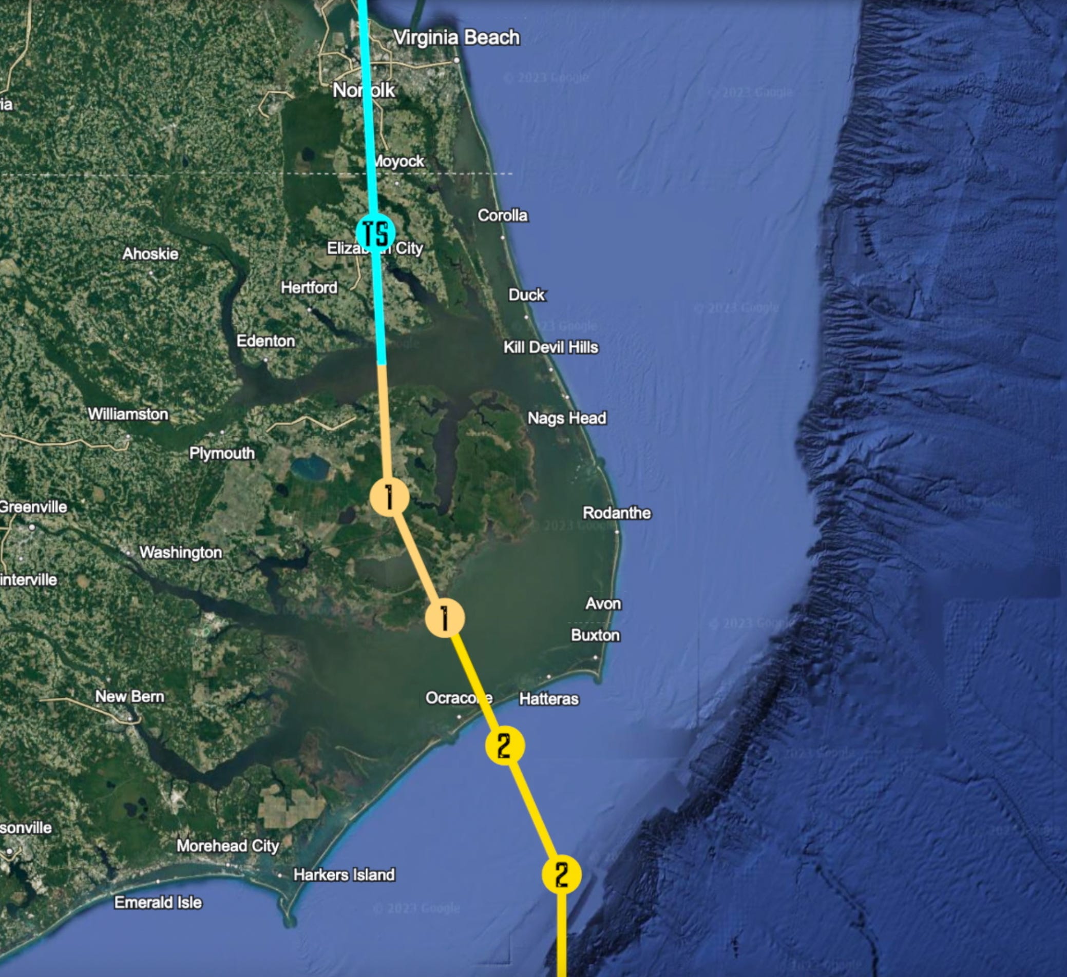
By 6 am, the eyewall of Hurricane Imani is just miles away from the U.S. shoreline. Extreme Wind Warnings (advisories made specifically for tropical cyclones, issued when 1-minute sustained surface winds are expected to be 115 mph and greater) are issued for Virginia Beach, Norfolk, Northampton, Hampton, and Poquoson counties in Virginia; and Currituck, Pasquotank, Dare, and Camden counties in North Carolina. Just as the sun’s light creeps above the horizon, feebly penetrating Imani’s thick, wetly woolen curtains, conditions become an embroiling whiteout. The Hurricane’s western eyewall grinds ashore around 6:40 am EDT, and at this time, the storm’s motion has shifted slightly again, now moving due westward at 10 mph. Landfall is looking to be just south of the North Carolina-Virginia border.
Twenty minutes later, the NHC stresses a dire, blood-chilling language in their 8 am bulletin:
NWS National Hurricane Center Miami FL
800 AM EDT Fri Sep 10 2027
…HURRICANE IMANI 2 HOURS FROM LANDFALL…
…MAXIMUM SUSTAINED WINDS ARE 120 MPH, AND MINIMUM CENTRAL PRESSURE REMAINS STEADY AT 937 MB. IMANI REMAINS A VERY POWERFUL AND DANGEROUS CATEGORY 3 HURRICANE. CATASTROPHIC AND LIFE-THREATENING STORM SURGE LIKELY IN THE CHESAPEAKE BAY BASIN AND NORTH CAROLINA OUTER BANKS. UNSURVIVABLE WATER-RISE POSSIBLE IN THE CITY OF NORFOLK.
With the carving vehemence of a shark’s serrated teeth, Hurricane Imani’s eyewall bites down on the Chesapeake-Potomac basin, gnashing the estuarine land to a moistened, mawkish pulp. Storm surge gauges rocket to devastating levels at the behest of the ferocious whipping of the winds. Enormous swells collide into the Virginia Beach oceanfront, where anemometers (placed beforehand by cyclone researchers) sustain the strongest winds thus far recorded, at 112 mph. Waves roll in on top of the flooding, shattering windows and busting down doors of the hotel lobbies. Within an hour, surge levels have already risen to 11.9 ft. in Virginia Beach, 10.4 ft. in Hampton Roads, 10.1 ft. in Norfolk, 8.7 ft. at Corolla, and over 6 ft. in Kitty Hawk and Ocean City. Barometers descend rapidly. A NOAA saildrone, bobbing in the center of Imani’s clouded eye just off the shore, maintains a solid ~940 millibar air pressure at the surface.
By now, it seems that every single news channel and media outlet has a reporter somewhere in the Mid-Atlantic states, standing amongst puddles in parking lots or street gutters, the folds of their rain jackets rippling in the wind. The majority of live, mainstream coverage of the storm fails to represent the devastation occurring in the coastal counties of Virginia and North Carolina.
Shingles are being stripped off like velcro straps. Water rolls into every crease and crevice it can reach. Streets disappear under blankets of rippling bronze liquid. Trees in Currituck Peninsula snap, bend, and crack in a raining symphony of green snow and deadly splinters. The maze of suburban homes in Norfolk are swallowed by the swollen Chesapeake, as the northwestern quadrant of Imani’s eyewall hits the nail of the city on the head. The tidal wave surges up the Elizabeth River, penetrating deeply into the downtown heart of Norfolk. Over three-quarters of the city becomes inundated with at five feet of seawater, while maximum heights closer to the coast are nearly doubling in just an hour, between 8 am to 9, now reaching a depth of ~15 feet above normally dry ground.

The Water Ascends (A First-Hand Account of the Storm’s Approach).
In Hampton, Virginia, a former U.S. Air Force pilot by the name of James Douglas, found both he and his family in a mortal danger that was all too familiar come the morning of September 10th. Douglas was a small-town man by blood; once a resident of the southern farmland, he was prompted to move his family from their beloved rural home in Fair Bluff, North Carolina, after Hurricane Florence’s flooding in 2018 left the first floor of their house diseased with black spores, and rotting from the drywall-out. Relocating 242 miles to the northeast, near his father’s home in Hampton, Douglas believed he had moved far enough away from the tropics to no longer fear the possibility of a significant Hurricane landfall over his new home. His father assured him by saying, “I’ve stood outside in every one of those damn Hurricanes over the years, and not one has blown out my cigar.”
When Hurricane Imani came to dominate the headlines and TV screens, Douglas’ 17 year-old daughter, Adelaide, could hardly watch. The memory of Hurricane Florence’s impact had seemed to linger in her vividly; she would awake screaming on nights where thunderstorms roared outside, and she refused to swim in the ocean when they took vacation trips to Virginia Beach. She had been 8 years old when Florence made landfall in 2018, but she’d never forgotten the horror of wading through that terrifying filth of mud, debris, and grossly sticky river water.
Thus, as the forecast track for Imani unpredictably jittered as she approached, James Douglas was left with a choice: listen to the pleadings of his wife and daughter, who wanted to drive to Richmond to stay for the weekend… or the advice of his father, who cited Imani’s predicted landfall in North Carolina as being too far away to bring them dangerous impacts. “Any rain here,” James Sr. explained, “will drain out into that ol’ Chesapeake faster than a buck can run down a doe in December.” So Douglas took the advice of his father, and convinced his wife, Anne, that they would be fine to ride out the storm. Quietly, he hoped that he would be right.
But Imani had other plans. The last-minute track divergence on the 9th shifts the Hurricane’s forecast track into southeastern Virginia… for the Douglas’, it’s their worst fears come true. Frantically, James tries to gather his family together to evacuate inland—unfortunately, about 800,000 other people have the exact same idea. Highway maps pour red lines over the cobweb of interstates, indicating blocked traffic for miles upon miles along the freeways. Douglas asks ‘Sid’—the family’s personalized, online, artificial-intelligence accomplice—what their course of action should be. Sid, instantaneously analyzing terabytes of real time information regarding Imani, and factoring in the Douglas’ family history with Hurricanes (Adelaide had frequently consoled with Sid on stormy nights and other occasions of personal distress), recommends they ride out the storm, due to the untenable traffic clogging the freeway’s arteries.
Consequently, James and Anne collect candles, fill their bathtubs, and stuff toilet paper rolls into empty wood stain cans. They pour lighter fluid that James had bought for the backyard grill into the absorbent folds of the densely crammed toilet paper, knowing these impromptu stoves would burn long enough to boil bottles of water if necessary (Adelaide saw this done on Instagram and had added it to her improvised Hurricane checklist).
Every five minutes, an emergency alert bulletin screams through the house, droning on in a voice of cold mechanics, listing ominously the counties under a Hurricane Warning. The red label is reflected off the lens’ of Adelaide Douglas’ glasses, as she fixates her gaze on the screen.
“Dad,” she says shortly, without looking away.
James is near the back door, busily packing beach towels into the narrow slit between the door and the threshold. “Not now, Adele,” he grunts, squeezing in the towels tighter.
“But dad!” Adelaide cries, running her hands through her hair (this is her subconscious response to stress). “Look!”
James Douglas nearly yells at his daughter’s pestering whines, until his eyes catch sight of the map displayed on the TV. Rising to his feet, James walks closer to the screen. The weatherman waves his hand across the map, which is overlaid with colors of violet, red, and orange across the entirety of Hampton. On display at this moment, James spots their street, Old Meribeth Road, under the violet haze labeled ‘14-18 feet’. He feels the presence of his wife move up behind him, and the forward facing imploring gaze of Adelaide’s pleading eyes.
“We have to try and get out of here,” James concludes firmly, feeling the protective adrenaline of both husbandry and fatherhood being released into his veins. Taking nothing but an extra pair of clothing each and some light toiletries, James leads his wife, daughter, and father out the front door. The rain outside was already battering fiercely, coming down obliquely. Sprinting across the front yard and driveway, the Douglas family piles into James’ SUV. They are already shivering; and whether this is more from the wet cold, or their intense trepidation, is indistinguishable.
The drive out of Old Meribeth is almost immediately stalled. While power to the streetlamp has been maintained up until this point, Imani’s winds are already tearing at the dense clusters of oak tree canopies throughout Hampton’s neighborhoods. Leaves and twigs rain down in a downpour nearly as dense as the Hurricane’s; the debris clatters on the Douglas’ car, sounding like pea-sized hail. They pass streets that are hopelessly blocked with honking horns and peppermint lights… while others seem completely abandoned.
They are on the road less than 5 minutes before coming across a downed tree along Madrid Drive, which unreservedly blocks their forward progress. James reverses back onto Wilderness Road, only to travel half a mile down its length before being halted by a wooden blockade of splintered trees and impenetrable piles of vegetative debris.
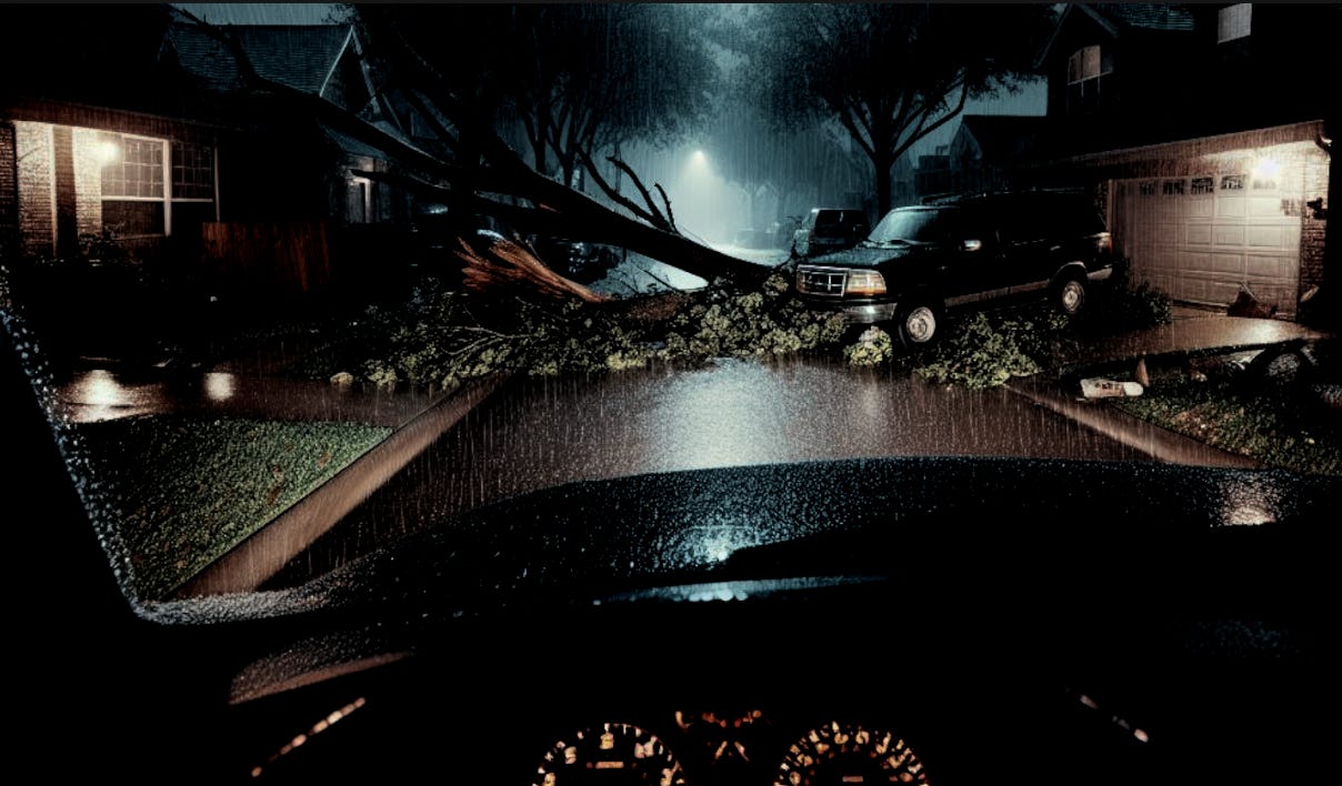
Adelaide hyperventilates in the back seat; her grandfather hugs her close, urging her to calm down. James curses obscenely under his breath, pulls back onto Black River Road. With the left side looking like a stagnant quagmire of cars, James turns to the right, but is once again stopped in his tracks. Floodwaters have risen over the road a mile to the east—and while likely not too deep to feasibly drive through, the presence of a downed power line submerged in the pool forces James to turn around yet again. Another ten minutes of fruitless searching for a way out of their neighborhood is the last straw for the Douglas’s. They realize they cannot escape the reality of their situation, anymore than they can Imani’s imminent floodwaters. They have no choice but to return to their home on Old Meribeth Road… which lies only just a football-field’s length away from the Branch Back River.
The following events that transpire at the Douglas’ residence, as Hurricane Imani screamed ashore during the overnight and early morning hours of September 10th, 2027, is chronicled in journal entries by Adelaide Douglas:
——————————————————————————————
1:56 am. We are back home now, and have reluctantly hung our hats regarding the search for an escape route out of Hampton. I thought that, after we moved to Virginia, I’d never have to experience a Hurricane like Florence again. I suppose life must have different plans for me. The weather channel continues to speak callously of words such as, “Unsurvivable,” to describe the waters coming our way. What atrocious manners they have, to tell of our death and destruction with the same insolence a general speaks of his soldiers on the battlefield. Are we but statistics on a pedestal of casualties to be displayed to the world at a moment’s notice? Tonight, I pray that is not so.
3:49 am. I can’t sleep… the zephyrs are too loud, too terrible, for my mind to slip into a dreamful sleep. It felt like Christmas morning through the eyes of a child—except inverted, like the buzzing premonition of your imminent death, instead of exciting presents to magically appear beneath the evergreen tree. My family, we are tied to a railroad track with knots of ignorance. Imani is the train racing forward as fast and enlivened as her spinning wheels can carry her. She is our judge, jury, and executioner. We have made a terrible choice of judgement to dare underestimate this Hurricane… and she intends to make us pay the ultimate price for our insensible disrespect towards her. My dog, Rochester, she’s curled up beside me in my bed, looking like a furry cinnamon roll beside me. I try to use the radiating warmth of her body to comfort my fearful heart.
6:33 am. The relentless pace of the delirious conditions, on the other side of the thin veil that is my bedroom window, restrains my eyes from closing, making them too afraid to miss any chapter of this nightmarish story. Rochester is cuddled in my arms, upset by the persistent howling, folding her ears back on her head. Outside, the air looks like it’s filled with a hail storm of glittering shards of volcanic, onyx rock, lacerating the world to shreds. I whisper to Rochester that all will be fine… I think I’m talking to myself, more than I her.
6:58 am. I hear Imani’s whispers of death in my ear, and it’s more terrifying than words can describe. There’s a cry outside my door. I leap off my bed, only to feel my feet fly out underneath me. I splash into a shallow layer of water I hadn’t even realized was there. I scramble as carefully as I can in my slippery, sopping socks to the living room. There, I find my parents in a panic; my mother is throwing towels at the threshold of our front door, creating a brown slop that looked like the wetted, shaved mats of a poodle’s fur. It had been raining hard for hours, but I can’t imagine it was enough to flood our house to this extent. My heart is sinking with the fear that this is the ocean rising into our living room. It wracks my muscles with pale convulsions. The wind has risen to a whistle that is making the blood in my face drain to a cold vacuum. My father is yelling at me now to help him collect our valuables in harm’s way.
7:21 am. A particularly vicious gust just bellowed outside… I could’ve sworn, when it hit, that at any moment, our house was going to disintegrate like ashes in a fireplace. The power finally flickers for the last time, and it’s then that I feel my legs go numb, and I crumple into the water. I pull my knees against my chest, trying to stop their trembling. The rain and wind is a constant, wicked gale; they, together, are nature’s Bonnie and Clyde, for I knew they killed with glee—they killed with vehemence. And they wanted to kill us.

7:59 am.The light coming through the windows is still faint, but the inner rooms of our house remained plunged in an impenetrable darkness. The water is cold, rapid, and up to my waist, now. Our house is filling like a pool that’s been neglected to the elements for years, and is a cesspool of brown filth as a result. The freight train squeals its vulgar whistle—constant, ceaseless, unremitting. My mother decides to call 911—on speaker phone, I hear the dispatcher casually drawl: “Sorry, honey, but there ain’t no one coming to get you. I suggest you take a black sharpie, and write your social security number on all y’all’s wrists…” I cover my ears, unable to listen any further. I’ll never forget that voice, and the appalling words it spoke.
8:20 am. We are sitting between a dusty bin of Christmas lights, and the silent gray cylinders that are our water heaters. The four of us, we are cowering on the splintery plywood floor of our attic. Pink, cotton candy fluffs of insulation clinging to the static electricity on our feet. Blow us, the abstruse water is over eight feet dark, and sloshing up the steps of the attic ladder. The blue-gray light beaming through our skylight ripples, like the shadows of a thousand black crows flying in front of the sun. The rhythm of the gales matches that of the waves; a concrete synchronization of time passing before my eyes. I’m utterly exhausted from these terrible hours of fear, and I realize my body and soul has resigned. If Imani wants me… then she will take me. And there is nothing, in my humanity, that can do anything about it.
——————————————————————————————
Islands in the Stream.
Norfolk-Suffolk and Hampton-Northampton are connected by the nerve cells of the intricate bridges and tunnels that brave the crossing over—and under—the Chesapeake Tidal Basin. These aqueducts, however, were never designed with the structural intentions of surviving a Major Hurricane so colossal, that the fluid dynamics of both the water and the air, were inseparably intertwined from the intense heat and pressure. Inside Imani’s insoluble depths, the extreme conditions warped the ocean in directions unseen during normal circumstances, akin to the liquefaction of hydrogen and helium inside Jupiter’s core, beneath the shroud of that planet’s very own violent, swirling cyclones.
By 8:24 am EDT, cracks begin to develop along the constructively grandiose length of the Chesapeake Bay Bridge Tunnel. The saltwater above the tunnel, pressurized by its own weight of depth, rockets through these compromising fissures. The glossy, white tile interior of the tunnel becomes a foaming, jet-powered jacuzzi tub. At 8:58 am, a catastrophic tipping point is reached, and the tunnel crumbles impulsively, its fragments and remains scattered across the ocean floor. Sections of the Chesapeake Bridge itself also fail totally, rendering the water crossing length of Virginia Route 13 completely impassable.
~12 miles to the west, the Hampton Roads Bridge Tunnel is the next to collapse, doing so an hour later around 10:00 am EDT. The Hampton Roads Beltway bridge/tunnel follows, though only one section suffers total destruction. Over the James River, a 1,000 foot segment of the State Route 32 drawbridge succumbs itself to the riotous waters at approximately 10:42 am. The cities, towns, and settlements of coastal Virginia are severed from each other’s tentative handhold… making them fragmented islands amidst a sea of uproar, and wreckage.
At 10:05 am EDT, the highest storm surge from Hurricane Imani would be notched at 21.3 feet, at Ocean View Beach, Norfolk, Virginia. The catastrophic, unsurvivable tidal wave meticulously penetrates Ocean View’s densely packed, coastal neighborhoods, eating away at the houses like a woodpeckers beak through a trees hard, yet pulpy, bark. Homes here, as well as in nearby Cone’s Beach, East (and West) Ocean, Bay View, and Pinewell, are raised on very minimal stilts, if any at all. Imani sweeps past these meager, inadequate defenses with bloodthirsty ease. Hundreds of residences are completely destroyed.
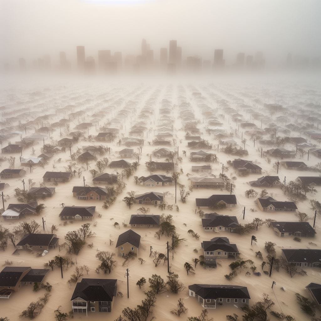
The surge pushes miles inland, flooding the vast majority of Norfolk with at least five feet of seawater. Buildings look like toys at the bottom of a filthy, rapidly filling bathtub. Driven by the unstoppable waters, people are forced onto their roofs like ants in an Amazonian flood, and into winds gusting over 140 mph. They huddle on the bare, bitingly coarse rooftops, hugging each other with their backs to the wind, like a rookery of penguins in an Antarctic blizzard. For some, however, even this is not enough… the carpet that is their homes fold underneath them, in capitulation to Imani’s waves, becoming spliced and split to a noxious soup of their starting materials. The sanguinary surge plunges Norfolk into a hell it has never seen before.
Virginia’s last, fragile sliver of tropical innocence, has been shamelessly shattered by Hurricane Imani. Two weeks of questions, uncertainty, and uneasiness, culminating in the East Coast’s worst cyclonic disaster since Hurricane Hugo in 1989.
Confusion, misinformation, and mixed messaging results in the failed evacuation of thousands of people in coastal areas only a few feet above sea-level. The erratic and unusual shift in Imani’s track, overnight on September 9th, had shifted the crosshairs onto an entirely different state. The panic in Virginia is so acute, that with the thousands of vehicles quagmired on the freeways as the Hurricane is approaching landfall, the death toll is (already) feared to be gruesome. Was it blissful ignorance? Or hapless forecast falsehoods?
The copper-tan haze of the furious whiteout slowed to a dreamy, carnal sedation. In Carova Beach, North Carolina, where six feet of storm surge has blanketed peninsular landscape, a man tentatively steps out onto the balcony of his raised home. The awning above him is torn and tattered, but mostly intact. He peers over the railing, at the chopping tumult slapping up against the stilts. His neck heightens his gaze upwards, across the length of the Currituck Peninsula, seeing a brown swamp of water in almost every direction except due west. The smashed remains of countless docks and piers bob atop the waves as inconsequential driftwood to Imani’s wrath. Then, the man looks upward further, to the tortured sky above; and while there is no perfection of clarity, or feeling of standing at the bloody pit of a cyclonic gladiator arena, the man can see the blue of a spectrally calm sky. He believes he’s met the midway point of the disaster—that only 3 more hours of violence must be endured, before the cleanup could begin, and the healing of hearts would ensue.
Perhaps the man was not wrong—for Carova Beach, the storm’s halfway mark may have been reached. But up north, amidst the winding, prolific watershed of the river once known as the Patawomeck, the nightmare would not be awakened to an ending after Imani’s landfall had passed.
For the “River of Swans”, and the millions of people who rely upon its charity for the aquatic ale that sustains their heart’s beat, the disaster was only just beginning…