
CATEGORY 5 HURRICANE
LIFESPAN: OCTOBER 5-12, 2024
MAX. SUSTAINED WINDS: 180 MPH
T-3rd Strongest Atlantic Hurricane by Wind Speed
MIN. CORE PRESSURE: 895 MBAR
T-4th Most Intense Atlantic Hurricane by Pressure. T-Most Intense Gulf Hurricane w/Hurricane Rita (2005). Most Intense Tropical Cyclone of 2024.
FATALITIES: 45
6 Missing
DAMAGE: $34.6 BILLION
10th Costliest Atlantic Hurricane
OVERVIEW
Credit: NOAA/CIMSS
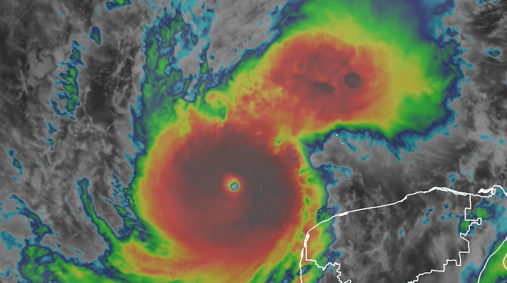
Hurricane Milton was the strongest and most intense Gulf Hurricane ever observed in the Atlantic Basin, tied with Hurricane Rita (2005), and is overall the 4th most intense Atlantic Hurricane in recorded history. Growing from the reconstructed remnants of a Caribbean trough, a stationary front, and an unnamed Tropical Storm from the East Pacific Ocean, Milton formed in the cradle of the Bay of Campeche on Oct. 5th, 2024 as a small, compact system. It was this small structural size, as well as an abundance of deep moisture, low wind shear, and ~88℉ turquoise seawaters across the southern Gulf, that enabled Milton to quickly undergo explosive intensification. Between 2 am EDT on Oct. 6th and 5 pm EDT on Oct. 7th, Milton’s winds increased by 135 mph, and his pressure cratered by 100 millibars.
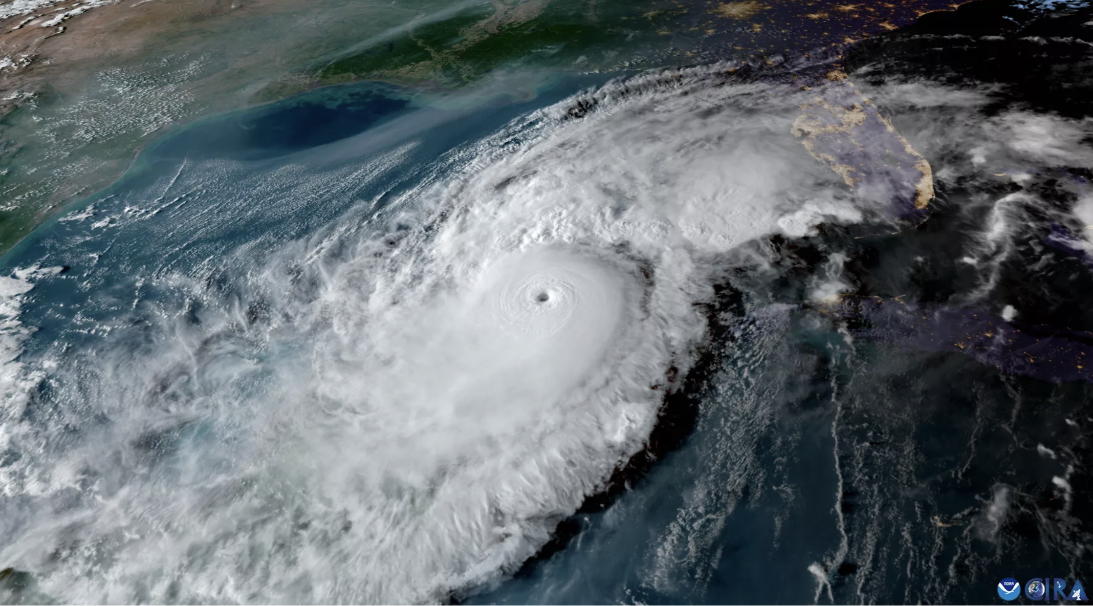
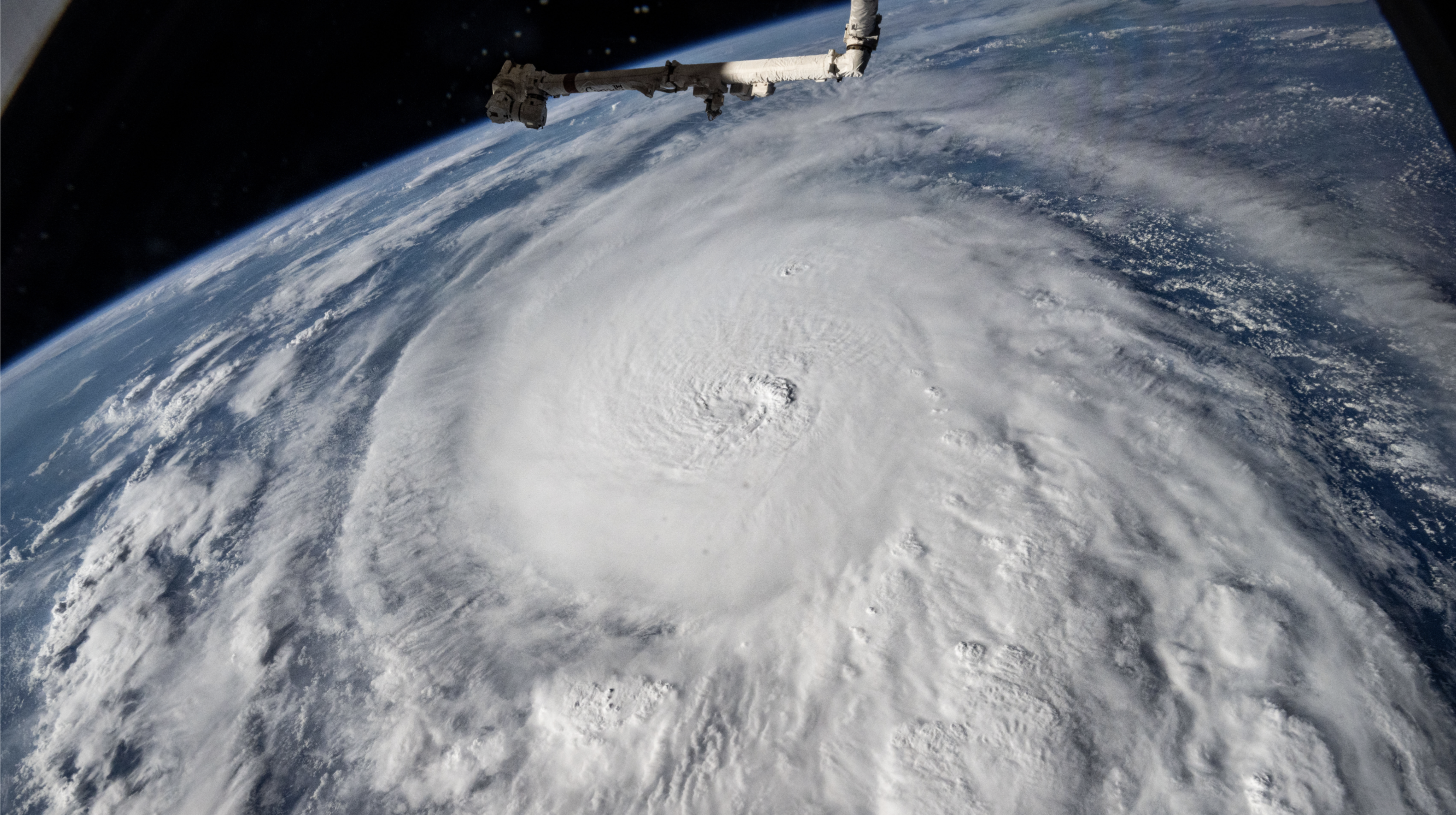
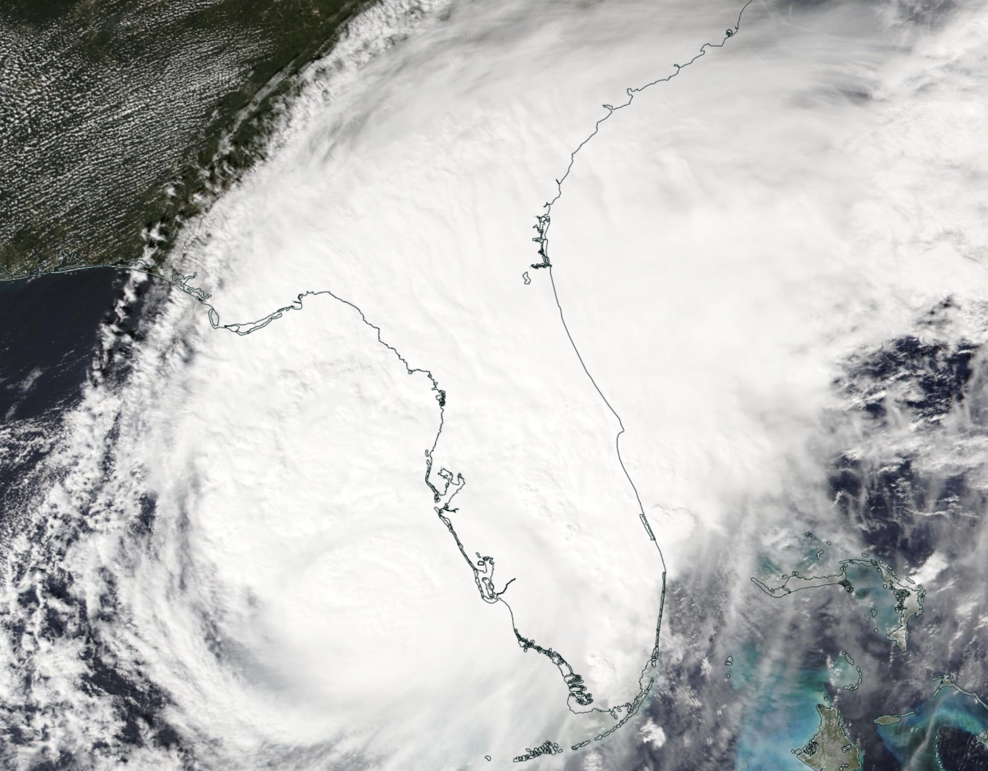
With a 3.8 mi-wide, pinhole eye surrounded by a bitterly cold (<-112℉) and absurdly moisture-packed Central Dense Overcast, Hurricane Milton achieved a 180 mph, 895 millibar peak intensity over the shallow waters of the Yucatán Platform at 8 pm EDT, Oct. 7th. Taking on an unprecedented, W-to-E path across the Gulf, Milton fluctuated between Cat 4 and 5 intensity over the next 24 hours, while passing to the N of the Yucatán Peninsula by just a few dozen miles. On the morning of Oct. 9th, the Hurricane entered a region of 35+ mph southwesterly shear, which began to rapidly eroded his circulation as he accelerated to the NE. Later that day, at 8:30 pm EDT, Milton made landfall near Siesta Key, Florida as a weakening 120 mph Category 3.
Though he was fast becoming hopelessly intertwined with a frontal boundary, the storm’s 100+ mph wind gusts, rainfall up to 19 in., storm surge up to 10 ft., and historic Tornado Outbreak speared a path of costly destruction through West-Central Florida. From St. Petersburg to Fort Pierce, 42 people lost their lives in the state, on top of 3-9 fishermen who drowned off the coast of Yucatán, Mexico earlier. An estimated $34.6 billion in total damages were done, making Milton the 3rd costliest Hurricane to strike the state of Florida, after Ian (2022) and Irma (2017). He dissipated on Oct. 12th in the SW Atlantic Ocean.
QUICK FACTS
- World’s Strongest Tropical Cyclone of 2024.
- Second Category 5 Hurricane of the 2024 Atlantic Hurricane Season.
- 4th Most Intense Atlantic Hurricane, behind Wilma (882 mb.), Gilbert (888 mb.), and “Labor Day” (892 mb.). Tied with Rita (895 mb.) as the Most Intense in the Gulf.
- First sub-900 mb. Atlantic Hurricane since Wilma (2005).
- First Time an Atlantic Hurricane was the World’s Strongest Tropical Cyclone since Maria (2017).
- 3rd Fastest Intensifying Atlantic Hurricane, behind Wilma and Felix (2007). Fastest Intensification in the Gulf. +90 mph and -82 mb. in a 17-hour period on Oct. 7th.
- Fastest Time for an Atlantic Hurricane to intensify from a Tropical Depression to a Category 5, jumping 35 mph to 160 mph in just 48 hours and 55 minutes.
- Secondary Peak of 165 mph and 902 mb. on Oct. 8th.
- Six Million Floridians Ordered to Evacuate.
- Landfall near Siesta Key, Florida at 120 mph on Oct. 9th.
- Spawned 46 Confirmed Tornadoes, including 3 EF-3s.
- 126 Tornado Warnings Issued on Oct. 9th, the Most in a Single Day for the State of Florida, and the 2nd Most of any U.S. State in a Single Day on Record, behind Alabama on April 27th, 2011.
- First Hurricane to Spawn an EF3+ Tornado in Florida since Agnes (1972).
- 10th Costliest Atlantic Hurricane on Record (not adjusted for inflation).
- First Major Hurricane to Make Landfall in the Tampa Bay Area since the 1921 Tampa Bay/Tarpon Springs Hurricane, and only the 3rd Overall in Florida’s State History.
- 5th Hurricane to Make Landfall along the U.S. Gulf Coast in 2024.
- Came less than Two Weeks after Helene devastated Florida’s Gulf Coast.
STORM TIMELINE
Tropical Depression 14 forms.
10:58 AM EDT, Oct. 5th
Tropical Storm Milton is named.
1:25 PM EDT, Oct. 5th
NHC predicts a direct landfall into Tampa Bay at Category 3 strength.

5:00 PM EDT, Oct. 5th
Milton rapidly reaches Hurricane status.
2:00 PM EDT, Oct. 6th
Hurricane Warning issued for Celestun-to-Rio Lagartos, Mexico.
5:00 AM EDT, Oct. 7th
Milton reaches Major Hurricane strength.
7:00 AM EDT, Oct. 7th
Milton explodes to Category 4 strength.
9:05 AM EDT, Oct. 7th
Milton attains Category 5 status.
11:55 AM EDT, Oct. 7th
Hurricane Warning and Mandatory Evacuations issued for the West Coast of Florida.
5:00 PM EDT, Oct. 7th
Hurricane Hunter Reconnaissance finds 180 MPH winds and an 895 MBAR pressure.


8:00 PM EDT, Oct. 7th
Closest approach to Mexico (~35 miles). Extreme tropical thunderstorms lash the Yucatán.
11:00 PM EDT, Oct. 7th
Milton re-attains C5 status after EWRC.

5:00 PM EDT, Oct. 8th
Despite resisting another EWRC, shear-induced weakening begins as Milton approaches Florida.
9:00 AM EDT, Oct. 9th
Fort Pierce, FL EF3 Tornado touches down. Surgewaters on the coast start to rise.

4:59 PM EDT, Oct. 9th
Extreme Wind Warning issued for Tampa Bay, FL.
6:36 PM EDT, Oct. 9th
Milton makes landfall near Siesta Key, Florida.

8:30 PM EDT, Oct. 9th
Wind gust of 107 mph recorded in Venice, FL. Storm surge peaks at 8+ ft. near Sarasota. Urban rain-flooding reported in Tampa and St. Petersburg.
~10:30 PM EDT, Oct. 9th
Power outages peak at 3.4 million customers.
6:00 AM EDT, Oct. 10th
Milton dissipates in the SW Atlantic Ocean.

5:00 PM EDT, Oct. 10th
IMPACTS
Milton’s bizarre formation and initial trajectory, which occurred exclusively in the shallower waters of the extreme southern Gulf, took him into a region that no other Hurricane of his strength had ever been documented. As he reached his historic peak intensity on the night of Oct. 7th, the storm was located just 60 miles NW of the coastal city of Progreso, Mexico.
Concern for the communities of the northern Yucatán Peninsula escalated early on, when Hurricane Milton’s slow eastward velocity began to deviate to the southern edge of the NHC forecast cone. This brought the possibility of a direct Mexico landfall into play – the result of which would mean a narrow yet catastrophic path of destruction through the State of Yucatán, due to the compact nature of Milton’s eyewall. A wave of panic buying ensued in Mérida – the largest city in SE Mexico. Near Cancun, ~2,700 people voluntarily evacuated from the island community of Isla Holbox during the storm’s approach.
Though he unnervingly inched much closer than initially forecast, Milton’s core ultimately stayed offshore of Mexico as he swam by. Tropical Storm force winds cut power for 12,000 people on the Yucatán Peninsula, with heavy rains causing flooding in Campeche and coastal surge initiating a few more mid-storm evacuations in Celestún (a couple of lives were claimed due to rough surf). Two boats from Progreso, Peyucsa 12 and Halcón 1, went missing at the height of the Hurricane. They were later found without any of their 7 combined crew members aboard.

As Hurricane Milton continued east, one of the most remarkable aspects of his evolution was the stability he was able to maintain at such an extreme, high-level intensity, going through two merger-like EWRCs that were minimally disruptive. This was especially unique considering his compact nature, as smaller Tropical Cyclones tend to oscillate in intensity much more dramatically than larger storms. Thus, it was incredibly fortunate that there was a wall of 30+ mph wind shear between Milton and Florida. By the time he drug himself across the State’s West-Central coastline (avoiding a worst-case-scenario landfall by coming in to the south of Tampa Bay, therefore sparing the exceptionally surge-vulnerable city), Milton had been reduced to a <120 mph “half-cane” undergoing Extratropical Transition. The overall effects of the storm’s landfall were still devastating, but without such a drastic, hostile environment of vertical shear present, an acute knife of high-end Cat 4 to Cat 5 damage might’ve plunged through some of Florida’s most urbanized population centers.
Severe impacts across America’s most Hurricane-tormented State began well before Milton’s eyewall arrived. Through the late morning and afternoon of October 9th, the Hurricane’s “right-front” (NE) quadrant trawled up Florida’s spine, sending chills through its low-top tropical supercells. That same corridor of strong wind shear had created prime conditions for tornadogenesis, and this incited a TC-related Tornado Outbreak of historic proportions. Multiple significant twisters touched down between the Everglades and Orlando, the largest of which struck Fort Pierce at EF3 strength and claimed 6 lives. It was the 5th deadliest and largest Outbreak in State History. Hurricane Irma (2017) had been the previous record holder of the latter title.
As darkness fell on Oct. 9th, Milton finally trudged ashore near the city of Siesta Key. Multiple locations recorded wind gusts over 100 mph within the badly eroded eyewall. St. Petersburg received the strongest remnant of the core, where a skyscraper construction crane was toppled onto the Tampa Bay Times building, and the roof of the Tampa Bay Rays’ Tropicana Field baseball stadium was partially ripped off. Rainfall amounted to 19 inches here. To the south in Sarasota and Manasota Key, a peak storm surge of 8+ feet inundated coastal areas, though no surge-related deaths were reported. Further inland, hundreds of water rescues were required due to freshwater flooding, and nearly three-and-a-half million households lost power.

In all, 12 direct deaths were attributed to Hurricane Milton’s impacts in Florida, in addition to 27 indirect deaths caused by storm preparations and post-landfall clean up.
IMAGE GALLERY


Credits: NOAA/CIRA, CIRA/RAMMB, NASA/Michael Baratt, NASA Worldview, NWS.
References: NASA Worldview (top image), Wikipedia, NHC.
EXPLORE MORE STORMS

Leave a comment