
CATEGORY 4 HURRICANE
LIFESPAN: SEPTEMBER 24-28, 2024
MAX. SUSTAINED WINDS: 140 MPH
T-Strongest Landfalling Atlantic Hurricane of 2024
MIN. CORE PRESSURE: 939 MBAR
Most Intense Landfalling Atlantic Hurricane of 2024
FATALITIES: 251
Deadliest Continental U.S. Hurricane since Katrina (2005)
DAMAGE: >$78.7 BILLION
5th Costliest Atlantic Hurricane
OVERVIEW
Credit: NOAA/CIRA
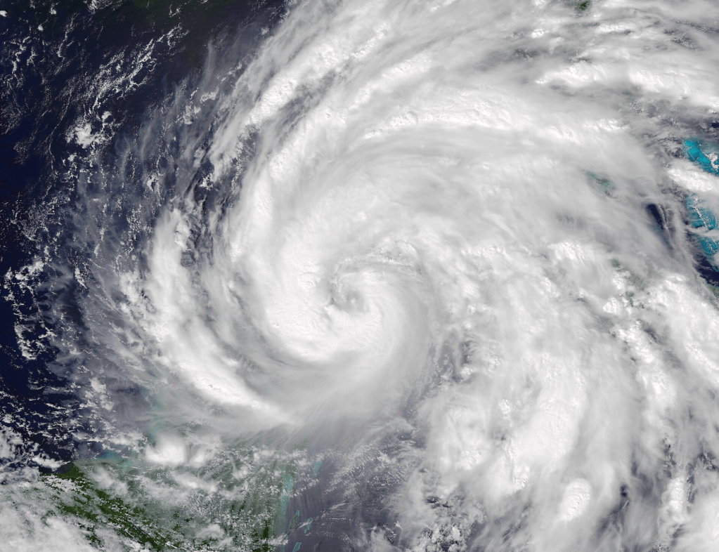
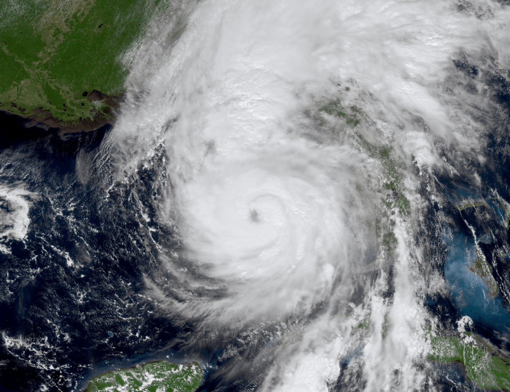
Hurricane Helene was an unusually colossal and catastrophic Tropical Cyclone that inflicted mass devastation across the Southeast region of the United States. A homegrown Atlantic system that formed from the interplay of a Central American gyre and the Madden-Julian Oscillation, Helene came together in the western Caribbean Sea on Sept. 24th, 2024. Initial development was somewhat steady in nature, owed to Helene’s sprawling size and persistent dry air intrusion. However, as she accelerated to the NE through the volatile eastern Gulf, rapid upshear deepening occurred, and she slammed into the Big Bend of Florida at a 140 mph, 939 mbar peak intensity on Sept. 26th.
Helene’s massive radius of gale-force winds were the primary driving force behind her immense destructive prowess. Though her core never came close to the West-Central Florida Coast, Tropical Storm-force wind gusts and unexpectedly heavy surge inundation thrashed every coastal settlement between Key West and Tampa Bay. An even larger, more violent surge decimated communities in Florida’s Big Bend, where the Hurricane’s eyewall crashed ashore at a forward speed of 24 mph. Her blazing northward velocity then enabled destructive winds to plunge through the State of Georgia, overnight on Sept. 27th, before her center tracked over the southern Appalachian Mountain chain. It was here, in the mountains of western North Carolina, eastern Tennessee, and northwestern South Carolina, that a rainfall-induced flood catastrophe ravaged hundreds of communities in a matter of hours.
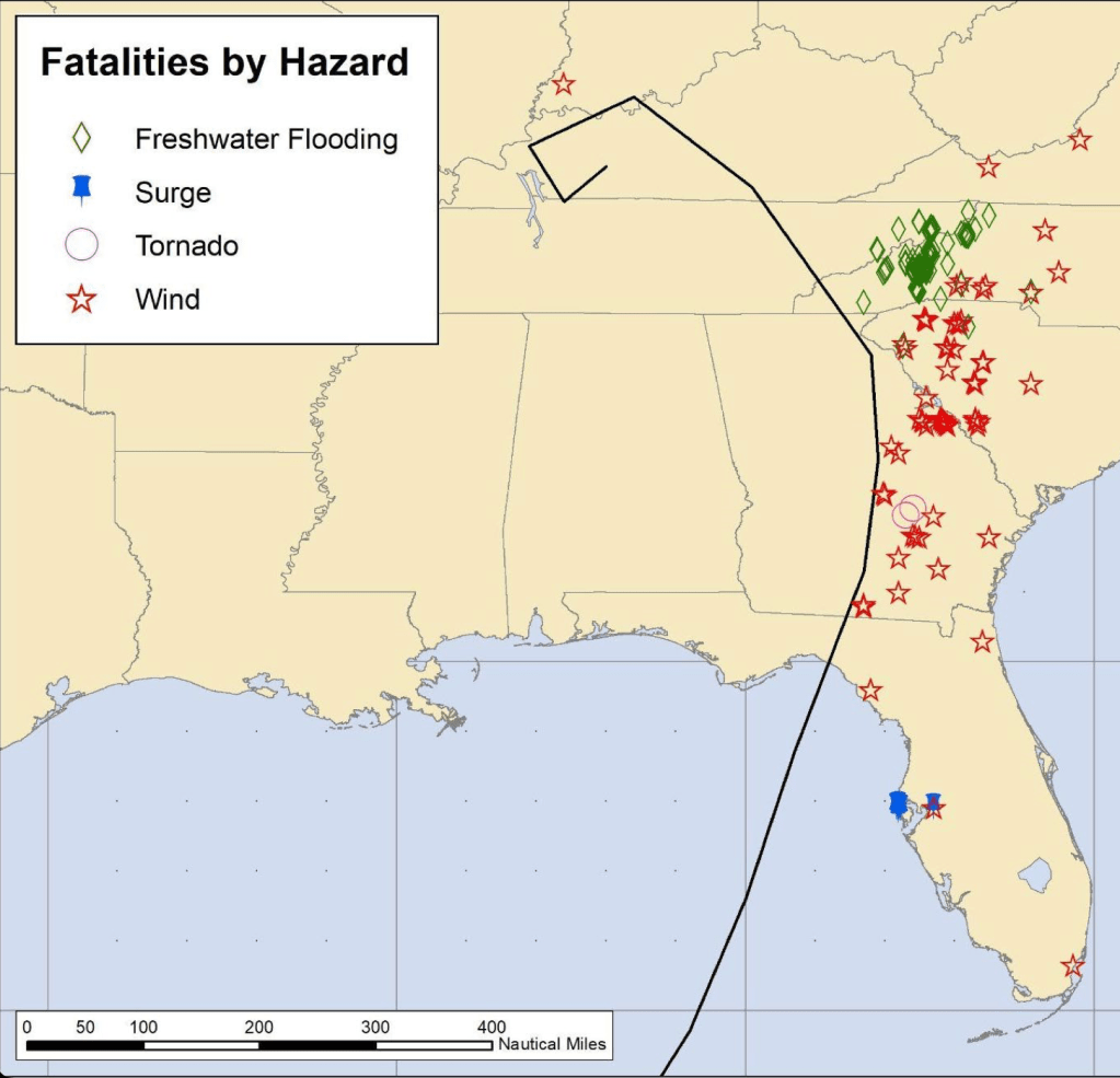
Upon entering Kentucky, Helene slowed into a cyclonic loop, merging with a cut-off low until she dissipated on Sept. 29th. Combining her impacts in Florida, Georgia, Tennessee, Virginia, and the Carolinas, Hurricane Helene claimed 251 lives, making her the deadliest Hurricane to affect the U.S. Mainland since Katrina (2005), the deadliest ever recorded in the State of North Carolina, as well as the deadliest Atlantic Hurricane overall since Maria (2017).
QUICK FACTS
- Deadliest Atlantic Hurricane since Maria (2017).
- Deadliest U.S. Mainland Hurricane since Katrina (2005).
- 5th Costliest Atlantic Hurricane on Record (not adjusted for inflation).
- Deadliest North Carolina Hurricane on Record.
- Costliest North Carolina Hurricane on Record.
- 3rd Largest Landfalling Hurricane on the U.S. Gulf Coast since 1985.
- 9th Most Intense Landfalling Hurricane in Florida.
- Strongest Hurricane to Strike the Big Bend region of Florida.
STORM TIMELINE
NHC detects Area of Interest in the SW Caribbean Sea.
1:11 AM EDT, Sept. 18th
Potential Tropical Cyclone Nine is designated 350 mi SSE of the western tip of Cuba.
10:59 AM EDT, Sept. 23rd
Tropical Storm Helene is named.
1:51 PM EDT, Sept. 24th
Hurricane Warnings issued for Quintana Roo, Mexico and the Big Bend region of Florida.
5:00 PM EDT, Sept. 24th
SpaceX Crew-9 Mission delayed to Sept. 28th.
Sept. 24th
Closest approach to Mexico (45 miles).
5:00 AM EDT, Sept. 25th
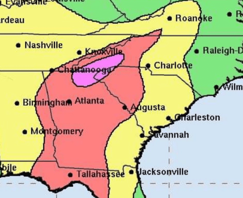
High Risk for Flash Flooding in the southern Appalachian Mountains is issued.
7:00 AM EDT, Sept. 25th
Helene becomes a Hurricane upon entering the Gulf.
10:57 AM EDT, Sept. 25th
Evacuations issued for coastal counties in the Big Bend.
2:00 PM EDT, Sept. 25th
Hurricane Hunters find that Helene is a Major Hurricane.
2:25 PM EDT, Sept. 26th
Category 4 status is achieved after winds increase to 130 mph.
6:20 PM EDT, Sept. 26th
Record storm surge of 6+ ft. inundates Tampa Bay, FL. Extreme Wind Warning issued for the Big Bend.

Image Credit: USGS Hydrologic Imagery Visualization and Information System (HIVIS)
4:30 to 8:30 PM EDT, Sept. 26th
Helene makes landfall S of Perry, FL near peak intensity.
11:20 PM EDT, Sept. 26th
15-20 ft. storm surge sweeps into the Big Bend.
11:58 PM EDT, Sept. 26th
Helene crosses into Georgia at 110 mph.

1:00 AM EDT, Sept. 27th
Power outages peak at 5.5 million customers.
2:00 AM EDT, Sept. 27th
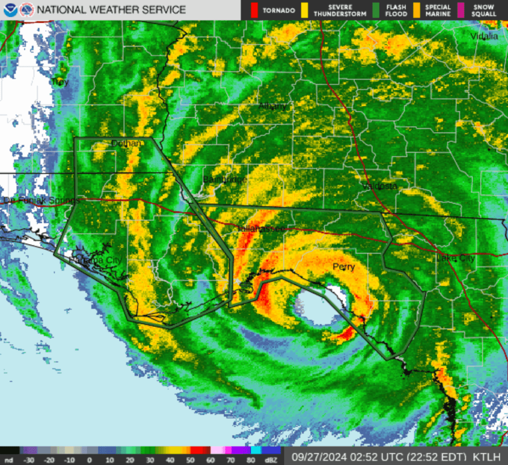
Helene’s core hits the southern Appalachian Mountains. 10 Flash Flood Emergencies are active at the same time. Disaster ensues.
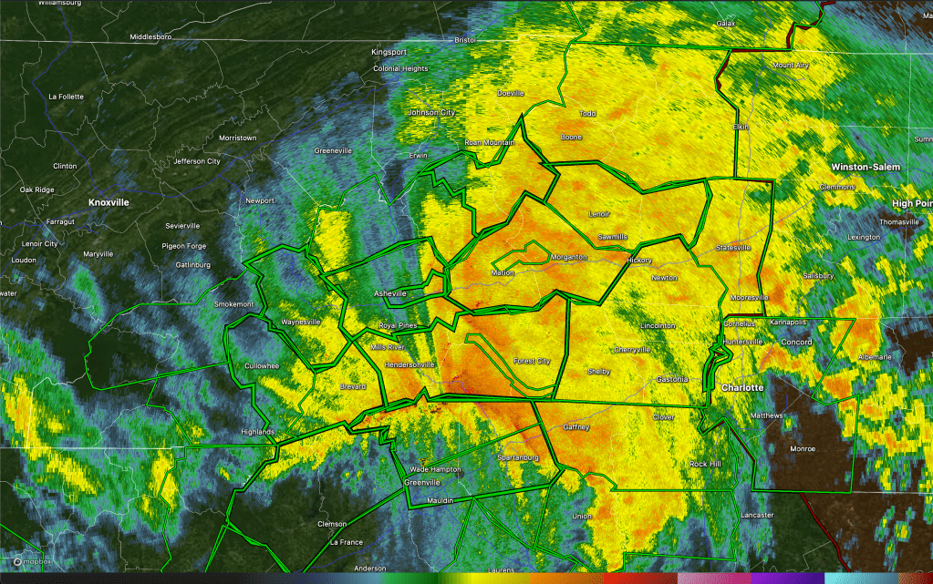
Image Credit: RadarScope
8:20 AM EDT, Sept. 27th
Flash Flood Emergency for a false report of a failure in the Walters Dam. Mass and extreme floodwaters devastate mountain towns in NC, SC, and TN.
3:30 PM EDT, Sept. 27th
All roads in western NC closed. Landslides cut off the city of Asheville. Rapid floodwaters destroy Chimney Rock. Hundreds of people declared missing. Recovery efforts begin in Florida.
Sept. 27-28th
Helene dissipates over the Tennessee Valley.
11:00 AM EDT, Sept. 28th
IMPACTS
FLORIDA

Helene brought all three of the major dangers in Hurricanes: Destructive winds, deadly storm surge, and extreme rainfall. The mass inertia of her extremely fast forward speed into landfall, coupled with her exceptionally large wind field, created widespread surge flooding along Florida’s Gulf Coast. Rather than being confined to the concave Big Bend, Helene’s storm surge impacts extended as far south as Naples, incrementally growing in severity the further north you traveled. Wind damage in locations that were directly sledgehammered by the eyewall was somewhat less intense than to be expected for a 140 mph Category 4, possibly due to rapid surface-level weakening induced by land friction in the final minutes preceding landfall. In total, Helene caused 34 fatalities and $13.9 billion in damages in Florida.

Tampa Bay is one of the most surge-vulnerable areas in America. Shallow shelf waters, a funnel-shaped bay, and the city sitting just a few feet above sea-level allow even passing storms to push an enormous volume of water onshore. A worst-case-scenario of 9+ ft. was predicted for Helene.
Even though the gigantic Hurricane’s core of strongest winds stayed ~100 mi to the city’s east, Tampa Bay still recorded a 7.2 ft. storm surge. Saltwater flooding in Pinellas County claimed 12 lives, damaged or destroyed 17,000 structures, and forced ~1,000 water rescues.
Image Credit: RadarScope


Above-ground water levels ultimately reached ~16 ft. at the height of the storm’s landfall. This peak inundation was recorded just south of Steinhatchee. Surgewaters also destroyed 90% of Keaton Beach and 70% of Horseshoe Beach nearby.
Although Florida experiences more Hurricane landfalls than any other State in the U.S., the Big Bend has historically avoided Cat 3+ impacts. According to NOAA, only two other Cat 3+ storms had struck this rural area of coastline since 1851. One of them was Idalia, whom made landfall just 13 months prior to Helene.

GEORGIA

Viciously scourging inland, Helene’s rocketing forward motion directly contributed to how deep her powerful winds could penetrate into Georgia. Sitting just to the north of the border with Florida, the city of Valdosta was one of the hardest hit, experiencing the full force of Helene’s swirling, 110 mph eyewall. Even with rapid weakening, the eastern half of the Hurricane’s core continued to generate 100+ mph wind gusts well over 200 mi inland, toppling trees, tearing roofs, and downing thousands of power lines. Damage in the State was estimated at $7 billion, while 37 people lost their lives.

Hurricane Helene was one the most significant inland tropical disasters for the United States, and Georgia was just the beginning. After pounding a huge stretch of Florida’s Gulf Coast, the storm’s core plowed through the Peach State unforgivingly, cutting a dramatic “dark scar” of power outages that was visible on nighttime satellite imagery.


With winds frequently gusting into triple digits, Helene caused heavy damage to tens of thousands of buildings, including this one in the city of Valdosta.


Falling trees turned out to be the deadliest impact from Helene in Georgia, with 26 people directly killed while inside either their homes or vehicles.
THE CAROLINAS

During the morning of Sept. 27th, as Helene continued her rampage N, her extremely moisture-laden and blustery core-remnant clipped the NW portion of South Carolina, dumping over 20 inches of rain through curtains of Hurricane-force wind gusts. The entire State was under a Tropical Storm Warning, and 1.3 million customers lost power – more than any other State affected by Helene. Major flash flooding was documented in low-lying areas, and 50 people were killed. Of these fatalities, 24 were a direct result of wind-related risks. Damage here totaled >$1.48 billion.

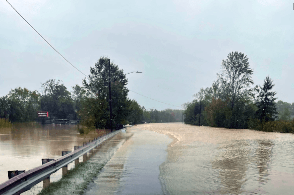
With the Sun beginning to peek over the gray horizon on the 27th, it was in the mountains of North Carolina where disaster struck in a violent flash. In the days leading up to landfall, Helene joined hands with a baroclinic cut-off low over the Southeast to produce a prolonged period of heavy rainfall over the S Appalachian Mountains. This added on top of a Predecessor Rain Event over the Southeast earlier in the week. By the time Helene was rumbling up through Georgia, the soils of W North Carolina and E Tennessee were saturated and waterlogged, unable to absorb further rainfall and primed to liquefy. Additionally, strong low-level convergence and orographically-driven upward vertical motion was conditioning the lower atmosphere to support extreme rainfall rates.
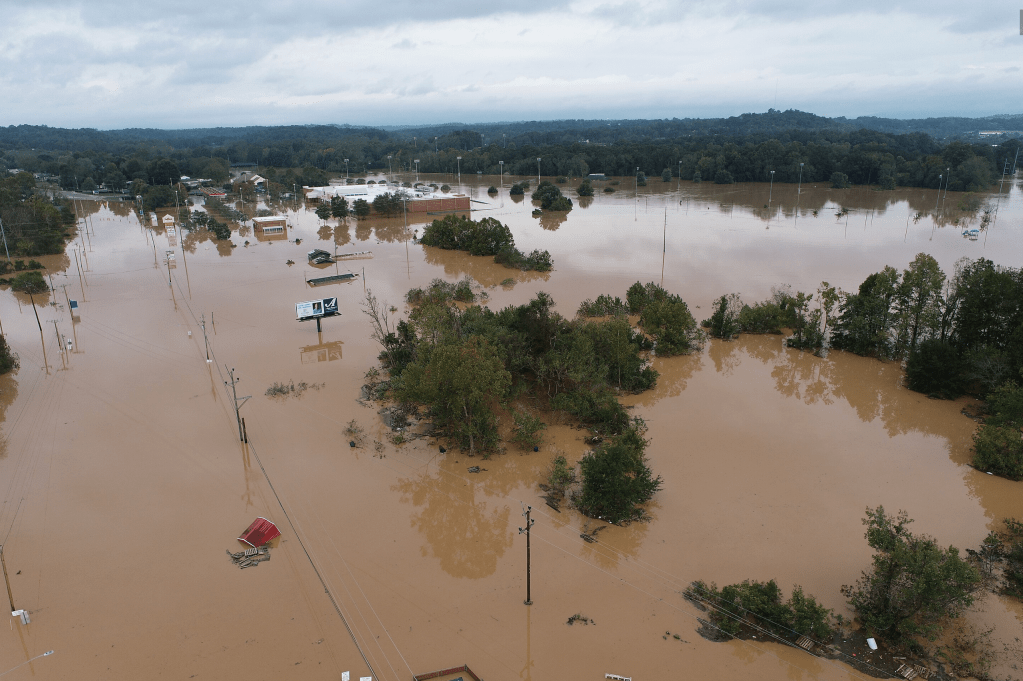
Helene’s core, which was now exploding into a 1,000+ mi-wide semicircle of convection due to continued interaction with the cut-off low, acted as the match that lit the fuse to this explosive precipitation bomb. It tracked directly over W North Carolina, subjecting this region to 72-hour rain totals of 20-30 inches (an event so extreme that it is estimated to have a <0.1% chance of happening in any given year). Already-swollen Appalachian rivers burst from their banks. Several dams threatened to fail, triggering large-scale emergency releases downstream. Over 2,000 landslides occurred in the mountains. At least 63 river and stream gauges shattered their all-time record flood levels, and 34 Flash Flood Emergencies were issued. By the end of it all, 107 deaths were blamed on Helene in North Carolina – 78 of which were a directly caused by floodwaters. Damage was estimated at a staggering >$59.6 billion, exacerbated by major infrastructure loss in the Appalachians.
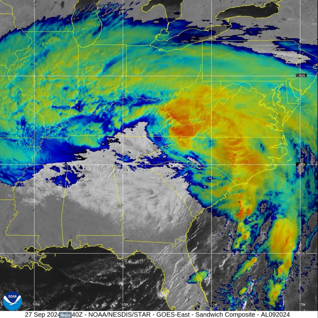
Helene’s merger with a cut-off low ballooned her into an immense hybrid system on Sept. 27th. While her worst flooding was concentrated in the S Appalachians, the States of Virginia, Ohio, Alabama, Kentucky, Illinois, West Virginia, and Indiana all received significant quantities of rain over the 48-72 hours post landfall.
Historic downpours, ferreted by wind gusts of 60-100+ mph, dilated rivers all across W North Carolina to record flood heights.
Image Credit: NCDOTcommunications (CC BY-SA 2.0)

At least 14 gauges broke 100+ year records, with the Swannanoa and South Toe Rivers surpassing their respective records by more than six and a half feet. This apocalyptic river flooding inundated and cut off towns like Asheville, Chimney Rock, Swannanoa, Spruce Pine, and Lake Lure.
Helene’s muddy floodwaters did not recede for days; and when they did, powdery drifts of sediment multiple feet deep hampered immediate recovery efforts.
Image Credit: NCDOTcommunications (CC BY-SA 2.0)


Some of the worst, long-standing destruction in W North Carolina was the decimation of basic infrastructure. Many people in remote, rural areas became isolated and trapped after landslides destroyed bridges and roads collapsed into raging rivers.
Image Credit: NCDOTcommunications (CC BY-SA 2.0)

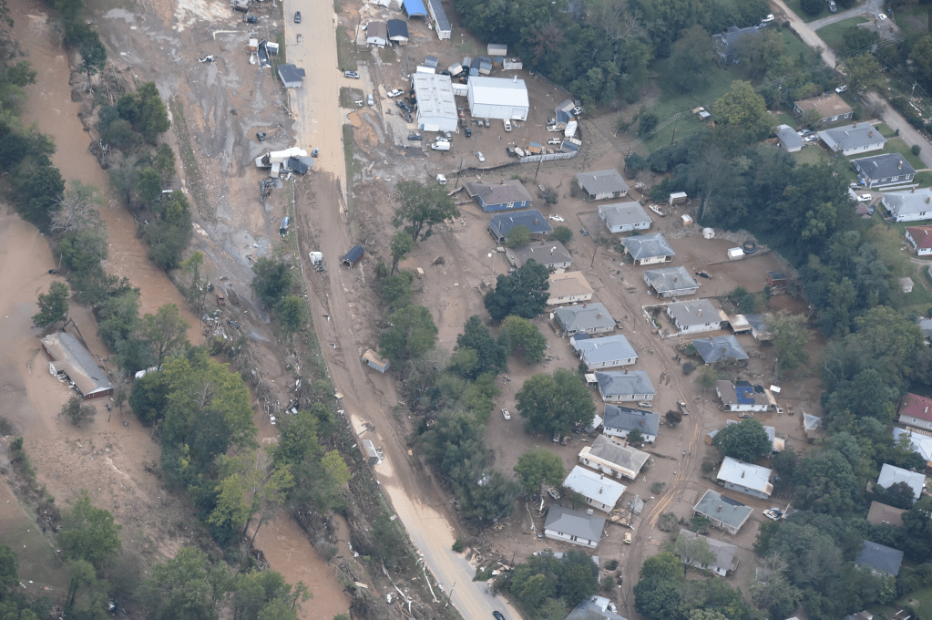
An estimated 125,000 homes were destroyed, along with critical electrical infrastructure and water treatment plants, leaving many residents without power, shelter, or clean drinking water for days/weeks afterward.
Image Credit: NCDOTcommunications (CC BY-SA 2.0)
Hurricane Helene’s floodwaters, mudslides, and debris flows, along with 822,000 acres of timberland that was blown down by wind (some slopes in the highest elevations were all but completely flattened by 100+ mph wind gusts, hundreds of miles inland from where the storm first made landfall).

The subsequent aftermath in W North Carolina was the most lengthy and controversial since Katrina in 2005, with dozens of communities still acutely suffering the effects of the storm as of early 2025.
References: NOAA/CIRA (top image), NASA Worldview, Wikipedia, National Hurricane Center.
EXPLORE MORE STORMS

Leave a comment