
CATEGORY 4 HURRICANE
LIFESPAN: AUGUST 17-SEPTEMBER 2, 2017
MAX. SUSTAINED WINDS: 130 MPH
First U.S. Major Hurricane Landfall since Wilma (2005)
MIN. CORE PRESSURE: 937 MBAR
Most Intense Texas Hurricane Landfall since Allen (1980)
FATALITIES: 107
DAMAGE: $125 BILLION
2nd Costliest Tropical Cyclone in World History after Katrina (2005)
OVERVIEW
Credit: SSEC/CIMSS UWM
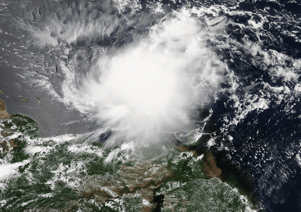
Hurricane Harvey was a powerful, slow-moving, and devastating cyclone that incurred extreme and widespread flooding across SE Texas. The 3rd of 10 consecutive Hurricanes that formed during the peak of the 2017 Atlantic Hurricane season, Harvey started out as a West African tropical wave, developing into a weak Tropical Storm in the Main Development Region (MDR) on August 17th. After passing through Barbados and St. Vincent and entering the Caribbean Sea, increasing wind shear promptly weakened him back down to a non-tropical entity. However, the system did not fully dissipate, continuing his journey westward as a ragged cluster of thunderstorms.
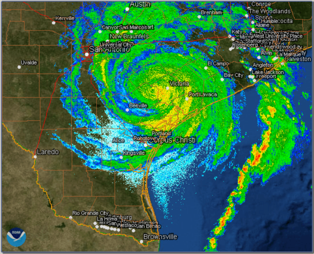
After crossing the Yucatán Peninsula and diving into the Bay of Campeche on August 23rd, more favorable conditions motivated Harvey to reorganize. The system’s central pressure rapidly began to drop as he moved WNW towards the Texas coast, bringing Harvey to Hurricane status on August 24th, and Major Hurricane status on the 25th. Unlike the vast majority of powerful storms that had made landfall along the northern Gulf Coast in the past, Harvey did not peak over open water and begin weakening as he approached land. Rather, he continued to rapidly intensify right up until his eye had fully crossed over San Jose Island, Texas late on August 25th, at which point he attained his maximum strength as a 130 mph, 937 mbar Category 4 Hurricane. This was the first Major (Cat 3+) Hurricane landfall in the United States since Wilma struck SW Florida in October of 2005, thereby ending a record-breaking 12-year drought of zero Cat 3+ landfalls in the US.
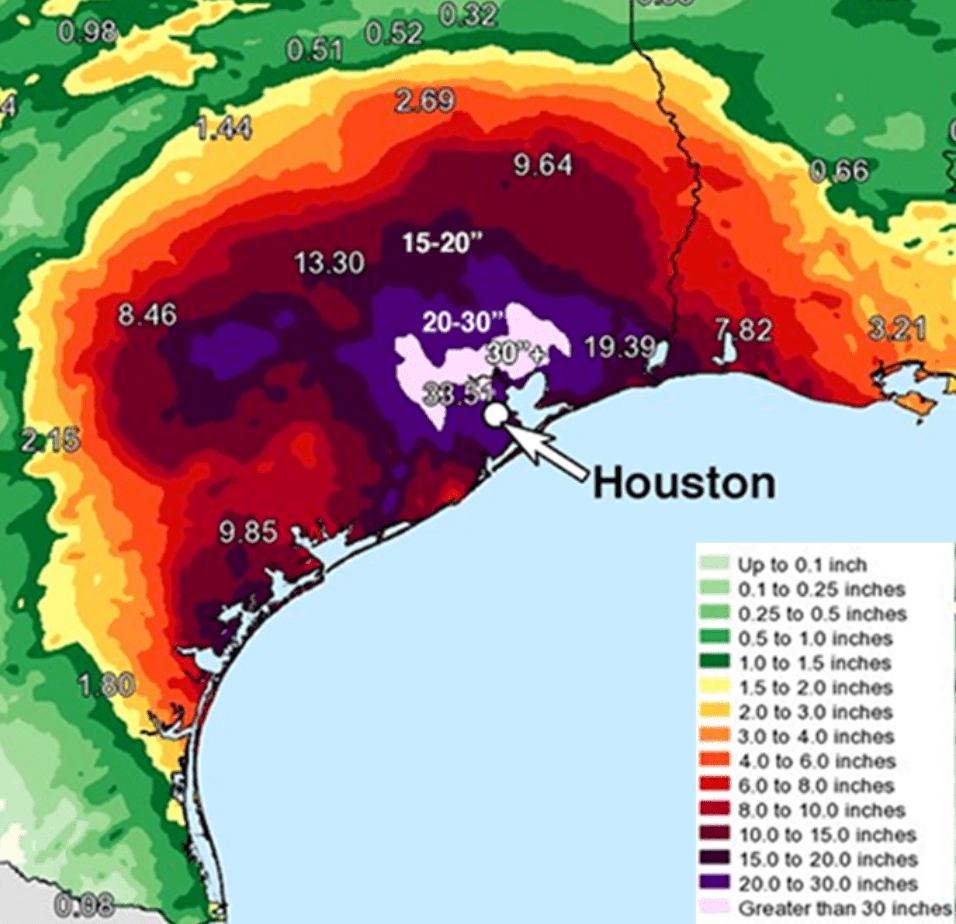
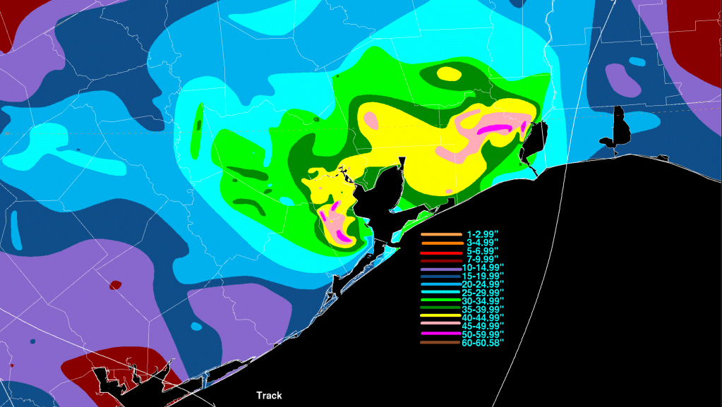
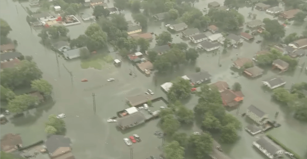
Drifting inland after decimating Aransas County at the coast, Harvey’s forward speed grated down to a tremendously slow crawl. By 1 am CDT on August 27th, the system’s center ceased all movement while located 70 mi ESE of San Antonio, Texas. Sitting just close enough to the Gulf to persistently pull in great quantities of sea-faring moisture, a meteoric flood disaster started to brew in SE Texas, as Harvey’s eastern half trained rainbands over the metropolitan city of Houston and its surrounding areas. Over the next four days, astronomical rain totals piled up, triggering catastrophic floods that displaced tens of thousands of people. The entirety of the greater Houston Area received at least three feet of rainfall, with a peak accumulation of 60.58 inches recorded in the town of Nederland. This officially made Harvey the wettest Tropical Cyclone in the history of the United States.
When the storm’s motion finally did resume on August 28th, it remained extremely slow and in the wrong direction, carrying Harvey back out over the Gulf. This re-energized his circulation with even more moisture, and the rain didn’t stop falling over East Texas until long after the relentless cyclone made his fifth and final landfall near Cameron, Louisiana on August 30th. By that time, unprecedented flooding was ongoing in Houston, where the majority of the 300,000 buildings and 500,000 vehicles Harvey flooded were located. The urban nature of the areas impacted catapulted this Hurricane’s damage total well past $100 billion dollars, making him the 2nd Costliest Tropical Cyclone ever recorded, as well as the 2nd Costliest Natural Disaster in the State of Texas. A total of 107 fatalities were blamed on the disastrous storm, 68 of which as a direct result of rainfall-triggered floodwaters and strong winds. Energy production in the Gulf, exacerbated by the closing of several oil refineries in the Houston Area, declined by 21% during the storm, leading to a brief but nationwide increase in gas prices.
QUICK FACTS
- 2nd Costliest Tropical Cyclone in World History, behind Katrina (2005), at ~$125 billion.
- Wettest Tropical Cyclone in United States History, dropping 60.58 inches of rain.
- First Major Hurricane Landfall in the United States since Wilma (2005).
- First Category 4 Hurricane Landfall in the United States since Charley (2004).
- Longest Lived Landfalling Hurricane in Texas, remaining at Tropical Storm status for 117 hours after landfall.
- Spawned 57 confirmed tornadoes.
- 2nd Costliest Natural Disaster in Texas State History, later surpassed by the 2021 Texas Power Crisis.
- First Major Atlantic Hurricane of 2017.
TIMELINE
Tropical Depression Nine forms in the MDR.
10:00 AM EDT, Aug. 17th
Tropical Storm Harvey forms.
4:00 PM EDT, Aug. 17th
System passes through the Windward Islands at 40 mph.
10:00 AM EDT, Aug. 18th
Harvey degenerates back to a tropical wave.
11:00 PM EDT, Aug. 19th
Harvey regenerates in the Bay of Campeche.
10:00 AM CDT, Aug. 23rd
Tropical Storm status is attained for the 2nd time.
11:00 PM CDT, Aug. 23rd
Hurricane Harvey is born.

Credit: SSEC/CIMSS UWM
12:00 PM CDT, Aug. 24th
Models indicate that steering currents will collapse once Harvey makes landfall. Extreme rainfall in E Texas predicted.
Aug. 24th
Harvey taps a warm eddy in the Western Gulf. Central pressure craters. Category 3 status is attained.
2:00 PM CDT, Aug. 25th
Harvey makes landfall over San Jose Island, TX at peak intensity.

10:00 PM CDT, Aug. 25th
Flooding in the city of Houston, TX begins due to Harvey’s outer rainbands.
11:00 PM CDT, Aug. 25th
Rainfall rates reach 2-3 in./hour in Brazoria & Galveston Counties. Flooding begins in S Houston suburbs. Vehicles stranded on Highway 288.
3:00 AM CDT, Aug. 26th
The Buffalo Bayou starts to rise. 1st major rainband sweeps through. Rain totals reach 10-15 in.
5:00 AM CDT, Aug. 26th
Flash Flood Emergency issued for the W side of downtown Houston due to the 2nd major rainband.
10:00 PM CDT, Aug. 26th
Harvey completely stalls out at 0 mph.
1:00 AM CDT, Aug. 27th
Rain totals in Houston reach 20 inches. Catastrophic flash flooding in urban and suburban areas ensues.
4:25 AM CDT, Aug. 27th
70% of Harris County is submerged in at least 1.5 feet of water. Buffalo and Green Bayous overflow. Rain totals reach 1 trillion gallons of water.
12:00 PM CDT, Aug. 27th
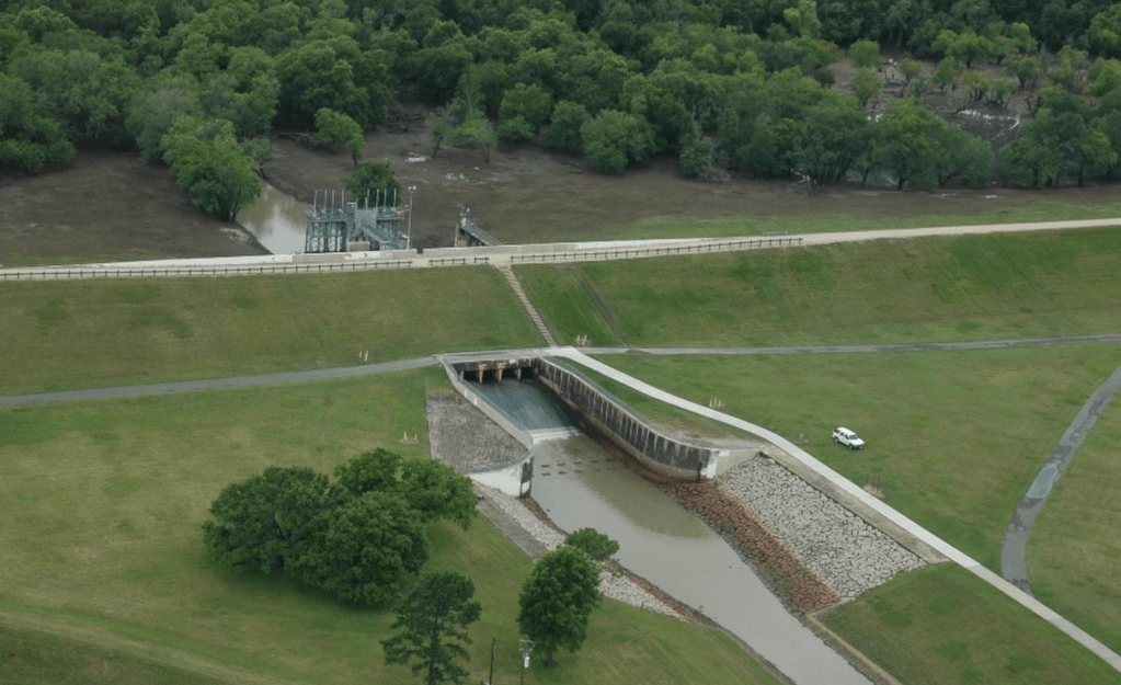
Addicks and Barker Reservoirs reach limit. Controlled releases flood even more neighborhoods along the Buffalo Bayou.
2:00 AM CDT, Aug. 28th
Harvey’s center re-emerges into the Gulf.
7:00 AM CDT, Aug. 28th
Buffalo Bayou reaches record peak of 67.46 feet. Thousands of neighborhoods and roads are inundated.
2:00 AM CDT, Aug. 29th
Harvey makes his fifth and final landfall near Cameron, LA. Rain totals exceed 50 inches.

1:00 AM CDT, Aug. 30th
Floodwaters in Houston begin to recede for the first time. Beaumont water supply compromised. Unprecedented peak rain total of 60.58 in. measured in Nederland.
6:00 PM CDT, Aug. 30th
Arkema Chemical Plant in Crosby, TX explodes due to floodwaters shorting critical refrigerating infrastructure.
2:00 AM CDT, Aug. 31st
Harvey dissipates inland as Hurricane Irma becomes a Major Hurricane 3,000 mi E of the United States.
Sept. 1st
IMPACTS

When Harvey first moved into the Gulf, there wasn’t much left of him. Just a tropical remnant; a band of thunderstorms. And then, 72 hours later, he was a Category 4 Hurricane, flamboyantly breaking the historic 12-year drought of Major Hurricane landfalls in the United States when he struck Aransas County, Texas late on August 25th, hitting towns like Rockport, Port Aransas, and Holiday Beach hard. It was an acute and violent preamble to the slow, prolonged, and excruciating death by 378 quadrillion raindrops that was coming for East Texas.
Intense rainbands began training over Houston shortly after Harvey made landfall 230 mi to the city’s SW. During the system’s subsequent stall-out and slow drift over the coastal Gulf, the “most significant Tropical Cyclone rainfall event in Unites States History, both in scope and peak rainfall amounts”, unfolded. A staggering 3-4 ft. of precipitation fell over the Houston Metro Area, creating vast urban flooding scenes not seen since Katrina (2005) in New Orleans. However, unlike past TC-related rain events (such as Allison in 2001 or Amelia in 1978), the zone of most intense rainfall was not confined to a relatively small area. Rather, the scale of the land area where multiple feet of rain was recorded was described as “literally and figuratively, overwhelming”, by the NHC. Based on probabilistic analysis, they also concluded that “it is unlikely the United States has ever seen such a sizable area of excessive tropical cyclone rainfall totals as it did from Harvey.”
Overall, Harvey’s unprecedented freshwater flooding claimed 103 lives in the State of Texas – 68 directly, 35 indirectly. >$125 billion in damages were tallied, the second highest total behind only Hurricane Katrina herself.
When Hurricane Harvey made landfall just N of Corpus Christi, TX, he was the Major Texas Hurricane landfall since Bret in 1999.
Credit: Terry Ross (CC BY-SA 2.0)
Overshadowed by the flooding in Houston and E Texas, Harvey’s impact in Aransas County on the night of Aug. 25th was tremendous.
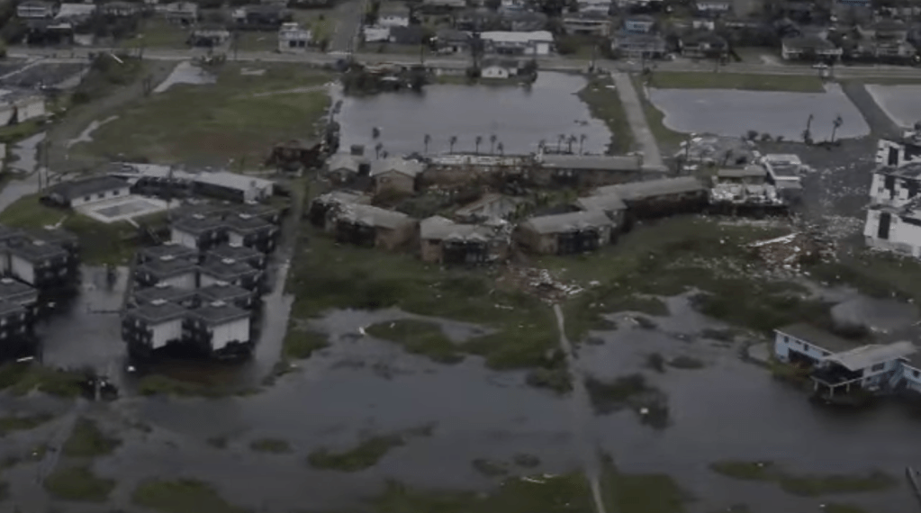

With peak wind gusts likely exceeding 150 MPH, entire blocks in Rockport were destroyed, while multiple boats in the marina were damaged or sunk.
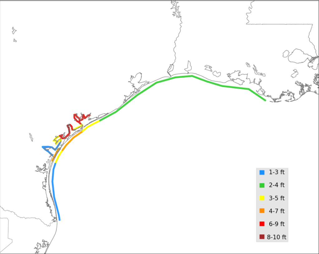
A maximum storm surge of 8-10 ft. also swamped San Antonio Bay and the surrounding areas. Holiday Beach suffered catastrophic destruction from both the surge and the violent winds.

Nearly every structure in Port Aransas was also severely damaged. The impact was so locally intense that the endangered Attwater’s prairie-chicken was thought to have nearly died out due to the storm.
Creeping inland, Harvey left all of Victoria without power or water, and Corpus Christi quickly measured 20 in. of rainfall. This, however, was just the beginning.


Between its flat topography, widespread area of impervious surfaces, and downstream position of subtropical watersheds, the city of Houston was in perfect position to be overtaken by freshwater flooding.
As the rains went on for days, the floodwaters rose. Across Texas, 300,000 homes were affected, with >17,000 of those sustaining major damage.


30,000 people in E Texas were displaced as their neighborhoods became submerged, prompting 17,000 water rescues.
Extremely widespread floods spread beyond the Houston Metro Area, inundating towns like Conroe, Beaumont, Bay City, and Port Arthur.

References: Wikipedia, National Hurricane Center.
EXPLORE MORE STORMS

Leave a comment